Gimli, Manitoba | |
|---|---|
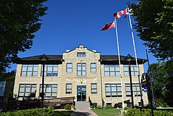
 Gimli Public School Building, constructed in 1915, and now site of the RM of Gimli's offices. | |
 Location of Gimli in Manitoba | |
| Coordinates: 50°37′55″N 96°59′20″W / 50.632°N 96.989°W | |
| Country | Canada |
| Province | Manitoba |
| Region | Interlake |
| Demonym: | Gimlungur (singular); Gimlungar (plural) |
| Founded | October 1875 |
| Incorporated as rural municipality | March 15, 1881[1] |
| Amalgamated with Town of Gimli | January 1, 2003[1] |
| Government | |
| • Mayor | Kevin Chudd |
| Area | |
| • Land | 318.10 km2 (122.82 sq mi) |
| Elevation | 222 m (728 ft) |
| Population | |
• Total | 6,569 |
| • Urban density | 319.25/km2 (826.9/sq mi) |
| Postal code | R0C 1B0 R0C 1B1 |
| Area code(s) | 204, 431 |
| Website | gimli.ca |
The Rural Municipality of Gimli is a rural municipality located in the Interlake Region of south-central Manitoba, Canada, on the western shore of Lake Winnipeg. It is about 75 kilometres (47 mi) north of the provincial capital Winnipeg. The rural municipality's population in the 2016 Canadian Census was 6,181, making it the 12th largest rural municipality by population. The RM of Gimli has an area of 318.75 km2 (123.07 sq mi), making it the sixth smallest rural municipality by area.
The unincorporated community of Gimli and the surrounding district were once an Icelandic ethnic block settlement, and the area, known as New Iceland, is home to the largest concentration of people of Icelandic ancestry outside Iceland. It also has significant Ukrainian and German communities, at 12% and 6% respectively.
The Town of Winnipeg Beach lies adjacent to its southeast corner, on the shores of Lake Winnipeg, between it and the Rural Municipality of St. Andrews to the south.
- ^ a b "Manitoba Communities: Gimli (Rural Municipality)". Manitoba Historical Society. Retrieved August 8, 2017.
- ^ "Population and dwelling counts: Canada, provinces and territories, and census subdivisions (municipalities), Manitoba". Statistics Canada. February 9, 2022. Retrieved February 20, 2022.