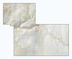
White Valley No. 49 | |
|---|---|
| Rural Municipality of White Valley No. 49 | |
 The abandoned Farwell Creek school | |
 Location of the RM of White Valley No. 49 in Saskatchewan | |
| Coordinates: 49°36′04″N 109°04′19″W / 49.601°N 109.072°W[1] | |
| Country | Canada |
| Province | Saskatchewan |
| Census division | 4 |
| SARM division | 3 |
| Federal riding | Cypress Hills—Grasslands |
| Provincial riding | Cypress Hills |
| Formed[2] | January 1, 1913 |
| Government | |
| • Reeve | James Leroy |
| • Governing body | RM of White Valley No. 49 Council |
| • Administrator | Tracey Schacher |
| • Office location | Eastend |
| Area (2016)[4] | |
| • Land | 2,026.88 km2 (782.58 sq mi) |
| Population (2021)[4] | |
| • Total | 352 |
| • Density | 0.2/km2 (0.5/sq mi) |
| Time zone | CST |
| • Summer (DST) | CST |
| Postal code | S0N 0T0 |
| Area code(s) | 306 and 639 |
| Highway(s) | Highway 13 Highway 633 Highway 614 |
| Waterway(s) | Frenchman River |
The Rural Municipality of White Valley No. 49 (2016 population: 478) is a rural municipality (RM) in the Canadian province of Saskatchewan within Census Division No. 4 and SARM Division No. 3. It is located in the southwest portion of the province near Eastend.
- ^ "Pre-packaged CSV files - CGN, Canada/Province/Territory (cgn_sk_csv_eng.zip)". Government of Canada. July 24, 2019. Retrieved May 23, 2020.
- ^ Cite error: The named reference
ruralincorpwas invoked but never defined (see the help page). - ^ "Municipality Details: RM of White Valley No. 49". Government of Saskatchewan. Retrieved May 21, 2020.
- ^ a b Cite error: The named reference
2016censusSKmuniswas invoked but never defined (see the help page).
