Rural Waiheke | |
|---|---|
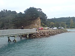
 Orapiu Bay wharf | |
 | |
| Coordinates: 36°48′04″S 175°07′26″E / 36.801°S 175.124°E | |
| Country | New Zealand |
| Region | Auckland Region |
| Ward | Waitematā and Gulf ward |
| Community board | Waiheke Local Board |
| Electorates | |
| Government | |
| • Territorial Authority | Auckland Council |
| Area | |
| • Total | 67.40 km2 (26.02 sq mi) |
| Population (June 2023)[2] | |
| • Total | 1,110 |
| • Density | 16/km2 (43/sq mi) |
Rural Waiheke comprises the eastern and southern parts of Waiheke Island in the Hauraki Gulf near Auckland, in New Zealand. Apart from small settlements at Ōmiha and Orapiu, the area south and east of Onetangi is mostly private farmland.[3] Waiheke Island Aerodrome is approximately in the centre of the island.
Whakanewha Regional Park is a 250 ha reserve with a substantial forest of native trees, a wetland and a beach.[4][5]
Stony Batter is a 20 ha scenic reserve containing a former defence installation with an extensive system of tunnels.[6]
- ^ Cite error: The named reference
Areawas invoked but never defined (see the help page). - ^ "Population estimate tables - NZ.Stat". Statistics New Zealand. Retrieved 25 October 2023.
- ^ "Community". Tourism Auckland. Archived from the original on 17 January 2013.
- ^ "Whakanewha Regional Park". Tourism Waiheke. Retrieved 25 August 2020.
- ^ "Whakanewha Regional Park". Our Auckland. Auckland Council. 24 October 2014.
- ^ "Stony Batter Historic Reserve". New Zealand Department of Conservation. Retrieved 25 August 2020.