Russellville, Ohio | |
|---|---|
 Looking east at the intersection of Main Street (Ohio State Route 125) and Columbus Street (U.S. Route 62) in Russellville | |
 Location of Russellville, Ohio | |
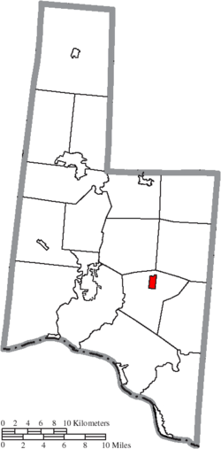
 Location of Russellville in Brown County | |
| Coordinates: 38°52′16″N 83°47′18″W / 38.87111°N 83.78833°W | |
| Country | United States |
| State | Ohio |
| County | Brown |
| Township | Jefferson |
| Government | |
| • Mayor | Paula J. Neu |
| Area | |
• Total | 0.73 sq mi (1.89 km2) |
| • Land | 0.73 sq mi (1.89 km2) |
| • Water | 0.00 sq mi (0.00 km2) |
| Elevation | 968 ft (295 m) |
| Population (2020) | |
• Total | 542 |
| • Density | 743.48/sq mi (286.91/km2) |
| Time zone | UTC-5 (Eastern (EST)) |
| • Summer (DST) | UTC-4 (EDT) |
| ZIP code | 45168 |
| Area code(s) | 937, 326 |
| FIPS code | 39-69316[3] |
| GNIS feature ID | 2399147[2] |
Russellville is a village in Jefferson Township, Brown County, Ohio, United States. The population was 542 at the 2020 census.
- ^ "ArcGIS REST Services Directory". United States Census Bureau. Retrieved September 20, 2022.
- ^ a b U.S. Geological Survey Geographic Names Information System: Russellville, Ohio
- ^ "U.S. Census website". United States Census Bureau. Retrieved January 31, 2008.