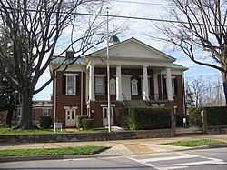
Rustburg, Virginia | |
|---|---|
 Former county courthouse, now a museum | |
 Location of Rustburg, Virginia | |
| Coordinates: 37°16′25″N 79°5′56″W / 37.27361°N 79.09889°W | |
| Country | United States |
| State | Virginia |
| County | Campbell |
| Area | |
| • Total | 12.6 sq mi (32.7 km2) |
| • Land | 12.5 sq mi (32.4 km2) |
| • Water | 0.1 sq mi (0.3 km2) |
| Elevation | 886 ft (270 m) |
| Population (2010) | |
| • Total | 1,431 |
| • Density | 114/sq mi (44.2/km2) |
| Time zone | UTC−5 (Eastern (EST)) |
| • Summer (DST) | UTC−4 (EDT) |
| ZIP code | 24588 |
| Area code | 434 |
| FIPS code | 51-69536[1] |
| GNIS feature ID | 1500006[2] |
Rustburg is a census-designated place (CDP) in and the county seat of Campbell County, Virginia, United States.[3] The population was 1,585 at the 2020 census.[4] It is part of the Lynchburg Metropolitan Statistical Area.
The public high school in Rustburg is Rustburg High School. The public primary and elementary schools are Rustburg Middle School, Rustburg Elementary School, Yellow Branch Elementary School, Fray Educational Center, and Campbell County Technical Center.
- ^ "U.S. Census website". United States Census Bureau. Retrieved 2008-01-31.
- ^ "US Board on Geographic Names". United States Geological Survey. 2007-10-25. Retrieved 2008-01-31.
- ^ "Find a County". National Association of Counties. Retrieved 2011-06-07.
- ^ "American Community Survey 5-Year Data (2009-2022)".