Rustenburg | |
|---|---|
 | |
| Coordinates: 25°40′00″S 27°14′34″E / 25.66667°S 27.24278°E | |
| Country | |
| Province | |
| District | Bojanala |
| Municipality | Rustenburg |
| Established | 1851 |
| Government | |
| • Type | Municipal ward |
| • Mayor | Sheila Mabale-Huma[2] (ANC) |
| Area | |
| • Total | 282.42 km2 (109.04 sq mi) |
| Elevation | 1,170 m (3,840 ft) |
| Population (2011)[3] | |
| • Total | 549,575[1] |
| Racial makeup (2011) | |
| • Black African | 52.9% |
| • White | 40.4% |
| • Indian/Asian | 3.3% |
| • Coloured | 2.8% |
| • Other | 0.6% |
| First languages (2011) | |
| • Afrikaans | 41.2% |
| • Tswana | 27.9% |
| • English | 11.9% |
| • Sotho | 4.0% |
| • Other | 15.0% |
| Time zone | UTC+2 (SAST) |
| Postal code (street) | 0300 |
| Area code | 014 |
| Website | Rustenburg Local Municipality |
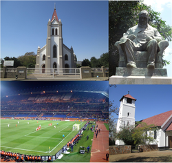
Rustenburg (/ˈrʌstənbɜːrɡ/; Afrikaans pronunciation: [ˈrœstənbœrχ], Afrikaans and Dutch: City of Rest[4]) is a city at the foot of the Magaliesberg mountain range. Rustenburg is the most populous city in North West province, South Africa (549,575 in 2011 and 626,522 in the 2016 census).[5] In 2017, the city's Gross Domestic Product (GDP) reached ZAR 63.8 billion,[6][7][8] accounting for 21.1% of the GDP of the North West Province, and 1.28% of the GDP of South Africa. Rustenburg was one of the official host cities of the 2010 FIFA World Cup, being in close proximity to Phokeng, the capital of the Royal Bafokeng Nation, where the Royal Bafokeng Stadium is located. The England national football team also used this as their base camp for the tournament.
- ^ "© Statistics South Africa". Stats SA. Stats SA. Retrieved 25 July 2012.
- ^ "© 2020 Rustenburg Local Municipality". Rustenburg Local Municipality.
- ^ a b c d "Main Place Rustenburg City". Census 2011.
- ^ "South African History Online - Rustenburg". sahistory.org.za. South African History Online (SAHO). Retrieved 25 July 2012.
- ^ "© Statistics South Africa - Rustenburg". cs2016.statssa.gov.za. Stats SA. Retrieved 25 July 2018.
- ^ "© North West Provincial Government - NORTH WEST PROVINCE PROFILE 2017" (PDF). nwpg.gov.za/. North West Provincial Government. Retrieved 27 June 2020.
- ^ "2020 IDG Communications, Inc. - Rustenburg: World Platinum Capital Deploys Smart City 'Gold Mine'". cio.com. International Data Group. 14 March 2019. Retrieved 27 June 2020.
- ^ "Rustenburg: World Platinum Capital Deploys Smart City 'Gold Mine' - 2019 Huawei Technologies Co., Ltd". e.huawei.com. Huawei. Retrieved 25 June 2020.


