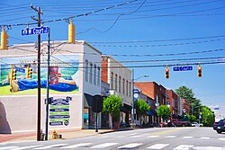
Rutherfordton, North Carolina | |
|---|---|
 Main Street (US 221) | |
| Motto: "A Minted Original" | |
 Location of Rutherfordton, North Carolina | |
| Coordinates: 35°21′51″N 81°57′41″W / 35.36417°N 81.96139°W | |
| Country | United States |
| State | North Carolina |
| County | Rutherford |
| Established | 1787 |
| Named for | Griffith Rutherford |
| Area | |
• Total | 4.14 sq mi (10.73 km2) |
| • Land | 4.14 sq mi (10.73 km2) |
| • Water | 0.00 sq mi (0.00 km2) |
| Elevation | 915 ft (279 m) |
| Population (2020) | |
• Total | 3,640 |
| • Density | 878.59/sq mi (339.23/km2) |
| Time zone | UTC-5 (Eastern (EST)) |
| • Summer (DST) | UTC-4 (EDT) |
| ZIP code | 28139 |
| Area code | 828 |
| FIPS code | 37-58460[3] |
| GNIS feature ID | 2407262[2] |
| Website | www.rutherfordton.net |
Rutherfordton (usually pronounced (/ˈrʌfɪn/ RUF-in) or (/ˈrʌftʌn/ RUF-tun), among other similar variations) is a town and the county seat of Rutherford County, North Carolina, United States.[4] The population was 3,640 at the 2020 census.[5]
- ^ "ArcGIS REST Services Directory". United States Census Bureau. Retrieved September 20, 2022.
- ^ a b U.S. Geological Survey Geographic Names Information System: Rutherfordton, North Carolina
- ^ "U.S. Census website". United States Census Bureau. Retrieved January 31, 2008.
- ^ "Find a County". National Association of Counties. Retrieved June 7, 2011.
- ^ "Explore Census Data". data.census.gov. Retrieved October 21, 2024.
