This article needs additional citations for verification. (February 2013) |
| Ruvuma Rovuma | |
|---|---|
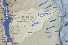
 Map of the Ruvuma River drainage basin. | |
| Location | |
| Country | Tanzania, Mozambique |
| Physical characteristics | |
| Source | |
| • location | Ruvuma Region, Tanzania |
| • coordinates | 10°45′00″S 35°40′00″E / 10.75000°S 35.66667°E |
| • elevation | 1,000 m (3,300 ft) |
| Mouth | |
• location | Indian Ocean |
• coordinates | 10°28′28″S 40°26′13″E / 10.47444°S 40.43694°E |
• elevation | 0 m (0 ft) |
| Length | 998 km (620 mi) |
| Basin size | 154,727.4 km2 (59,740.6 sq mi)[1] to 155,316.4 km2 (59,968.0 sq mi)[2] |
| Discharge | |
| • location | Near mouth |
| • average | (Period: 1979–2015)55.94 km3/a (1,773 m3/s)[3]
(Period: 1971–2000)2,286.3 m3/s (80,740 cu ft/s)[2] (Period: 1982–2013)890.8 m3/s (31,460 cu ft/s)[1] |
| Basin features | |
| River system | Rovuma River |
| Tributaries | |
| • left | Mlongasi, Likonde, Muhawesi, Lumesule, Mbangala |
| • right | Messinge, Lucheringo, Chinlezi, Lugenda |
Ruvuma River, formerly also known as the Rovuma River, is a river in the African Great Lakes region. During the greater part of its course, it forms the border between Tanzania and Mozambique. The river is 998 km (620 mi) long, with a drainage basin of ~155,000 km2 (60,000 sq mi) in size. Its mean annual discharge is 475 m3/s (16,800 cu ft/s) to 2,286 m3/s (80,700 cu ft/s) at its mouth.[4][2]
- ^ a b Development of Master Plan for Water Resources Management in Mozambique (PDF; 10,0 MB)
- ^ a b c "Central East Coast".
- ^ "GEF TWAP - Transboundary Waters Assessment Programme — GEF TWAP".
- ^ Nakayama, Mikiyasu (2003). International Waters in Southern Africa. United Nations University Press. p. 9. ISBN 92-808-1077-4.; online at Google Books