| S13 | |
|---|---|
| საერთაშორისო 13 | |
| Akhalkalaki-Kartsakhi | |
 | |
 S13 runs across the Javakheti Plateau | |
| Route information | |
| Length | 36.5 km[1] (22.7 mi) |
| Existed | 2011–present |
| Major junctions | |
| North end | Akhalkalaki |
| 3 | |
| South end | Turkish border (Kartsakhi |
| Location | |
| Georgia | |
| Municipalities | Akhalkalaki |
| Highway system | |
| |
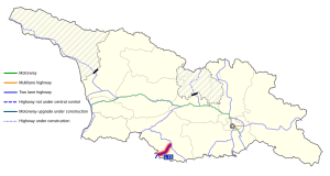
The S13 route (Georgian: საერთაშორისო მნიშვნელობის გზა ს13, Saertashoriso mnishvnelobis gza S13, road of international importance), also known as "Akhalkalaki-Kartsakhi", is a 36.5 kilometres (22.7 mi) highway route of "international importance" in southern Georgia from Akhalkalaki to the Turkish border near Kartsakhi. The route branches off from the S11/E691 highway on the northside of Akhalkalaki. It is a simple (two-lane) asphalt road through the highlands that are characteristic for the Samtskhe–Javakheti region. The road starts at 1700 m (5600 ft) above sea level and gradually climbs to 1970 m (6460 ft) before reaching the Turkish border at 1820 m (5970 ft), the 3rd highest border checkpoint in Georgia next to Georgia's 2nd largest lake (Kartsakhi Lake). After the Turkish border, the road continues to the Turkish D010 at Çıldır. It is the shortest route from Armenia to Turkey, shortcutting the E691 route.
- ^ "2022 List of highways of international and domestic importance" (in Georgian). The Legislative Herald of Georgia. 19 July 2022. Retrieved 22 August 2022.
