You can help expand this article with text translated from the corresponding article in Japanese. (February 2022) Click [show] for important translation instructions.
|
Sado
佐渡市 | |||||
|---|---|---|---|---|---|
| Sado City | |||||
| |||||
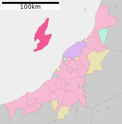
 Location of Sado in Niigata Prefecture | |||||
| Coordinates: 38°01′06″N 138°22′06″E / 38.01833°N 138.36833°E | |||||
| Country | |||||
| Island | Honshu | ||||
| Region | Chūbu | ||||
| Prefecture | Niigata Prefecture | ||||
| First official recorded | 135 AD | ||||
| As city of Ryōtsu | November 3, 1954 | ||||
| Town merger and new name | March 1, 2004 | ||||
| Government | |||||
| • Mayor | Ryugo Watanabe (since April 2020) | ||||
| Area | |||||
• Total | 855.69 km2 (330.38 sq mi) | ||||
| Population (June 1, 2023) | |||||
• Total | 48,195 | ||||
| • Density | 56/km2 (150/sq mi) | ||||
| Time zone | UTC+9 (Japan Standard Time) | ||||
| Address | 232 Chigusa, Sado-shi, Niigata-ken | ||||
| Climate | Cfa | ||||
| Website | www | ||||
| Symbols | |||||
| Flower | Daylily | ||||
| Tree | Thujopsis | ||||

Sado (佐渡市, Sado-shi) is a city located on Sado Island (佐渡島, Sado-shima/Sado-ga-shima) in Niigata Prefecture, Japan. Since 2004, the city has comprised the entire island, although not all of its total area is urbanized. Sado is the sixth largest island of Japan in area following the four main islands and Okinawa Island (excluding the Northern Territories). As of June 1, 2023, the city has an estimated population of 48,195 and a population density of 56.3 inhabitants per square kilometre (146/sq mi). The total area is 855.69 square kilometres (330.38 sq mi).


