| Safa and Marwa | |
|---|---|
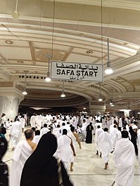
Left: A sign guides pilgrims toward Safa Right: Path of movement between Safa and Marwa, illustrated alongside the Tawaf or circumambulation of the Ka'bah | |
| Highest point | |
| Parent peak | Safa: Abu Qubais Marwa: Qaiqan |
| Coordinates | 21°25′25″N 39°49′38″E / 21.42361°N 39.82722°E |
| Naming | |
| Native name | |
| Geography | |
| Country | |
| Region | Hejaz |
| Province | Mecca |
| City | Mecca |
| Parent range | Hijaz Mountains |
Safa and Marwa (Arabic: ٱلصَّفَا وَٱلْمَرْوَة, romanized: Aṣ-Ṣafā wal-Marwah) are two small hills, connected to the larger Abu Qubais and Qaiqan mountains, respectively,[1] in Mecca, Saudi Arabia, now made part of Al-Masjid al-Haram. Muslims travel back and forth between them seven times in what is known as saʿī (Arabic: سَعِي, lit. 'seeking/searching or walking')[2] ritual pilgrimages of Ḥajj and Umrah.
Muslims run between the two mountains, which they believe was made a ritual as a tribute to Hajar's search of water for her child dying of thirst until she found a water source in the Zamzam Well. The space between the two mountains in which the pilgrims run is called al-Mas'aa.[1][3]
- ^ a b Hamw, Mahmoud M.; Isa, Abdul Ghani (2019). Makkah Al-Mukarramah: History and Milestones.
- ^ Mohamed, Mamdouh N. (1996). Hajj to Umrah: From A to Z. Amana Publications. ISBN 0-915957-54-X.
- ^ "IN PICTURES: The story of a Muslim ritual with roots dating back 5,000 years". Al Arabiya English. 2018-01-06. Retrieved 2020-07-06.


