Sahar
सहार | |
|---|---|
Village | |
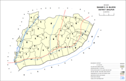
 Map of Sahar block | |
| Coordinates: 25°14′56″N 84°37′31″E / 25.24877°N 84.62535°E[1] | |
| Country | India |
| State | Bihar |
| District | Bhojpur |
| Area | |
• Total | 120.74 km2 (46.62 sq mi) |
| Population (2011) | |
• Total | 5,674[2] |
| Languages | |
| • Official | Bhojpuri, Hindi |
| Time zone | UTC+5:30 (IST) |
| PIN | 802208[1] |
Sahār (Hindi: सहार) is Gram Panchayat and community development block in Bhojpur district of Bihar, India. The sub-district contains 51 inhabited villages, including that of Sahar itself, with a total district population of 110,276 as of 2011. The village of Sahar has a population of 5,674, in 931 households.[2] Sahar was a major center of conflict during the wider Naxalite insurgency in Bhojpur in the late 1960s and throughout the 1970s.[3][4]
- ^ a b "Geonames.org. Sahār". Retrieved 2 April 2020.
- ^ a b "Census of India 2011: Bihar District Census Handbook – Bhojpur, Part A (Village and Town Directory)". Census 2011 India. pp. 27–35, 42, 46–47, 51–55, 59–61, 63, 71–84, 90, 92, 94, 185–186, 708–731, 752. Retrieved 1 April 2020.
- ^ Cite error: The named reference
Agrarian Movementswas invoked but never defined (see the help page). - ^ Cite error: The named reference
Peasant Revoltwas invoked but never defined (see the help page).

