Native name: | |
|---|---|
 Landsat image of Saibai Island | |
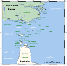
 A map of the Torres Strait Islands showing Saibai in the north central waters of Torres Strait | |
| Geography | |
| Coordinates | 9°24′S 142°41′E / 9.400°S 142.683°E |
| Archipelago | Torres Strait Islands |
| Adjacent to | Torres Strait |
| Major islands | Saibai, Kauamag |
| Area | 107.9 km2 (41.7 sq mi) |
| Length | 21.8 km (13.55 mi) |
| Width | 5.2 km (3.23 mi) |
| Highest elevation | 1.7 m (5.6 ft) |
| Highest point | unnamed |
| Administration | |
Australia | |
| State | Queensland |
| Local government area | Torres Strait Islands Regional Council |
| Island Region | Top Western |
| Largest settlement | Saibai (pop. 171) |
| Demographics | |
| Population | 340 (2021 census[1]) |
| Ethnic groups | Torres Strait Islanders |
| Saibai Island Queensland | |||||||||||||||
|---|---|---|---|---|---|---|---|---|---|---|---|---|---|---|---|
| Population | 340 (2021 census)[1] | ||||||||||||||
| • Density | 3.32/km2 (8.59/sq mi) | ||||||||||||||
| Postcode(s) | 4875 | ||||||||||||||
| Area | 102.5 km2 (39.6 sq mi) | ||||||||||||||
| Time zone | AEST (UTC+10:00) | ||||||||||||||
| LGA(s) | Torres Strait Island Region | ||||||||||||||
| State electorate(s) | Cook | ||||||||||||||
| Federal division(s) | Leichhardt | ||||||||||||||
| |||||||||||||||
Saibai Island, commonly called Saibai (Kala Lagaw Ya: Saybay, Saibai, Saibe), is an island of the Torres Strait Islands archipelago, located in the Torres Strait of Queensland, Australia. The island is situated north of the Australian mainland and south of the island of New Guinea.[2] The island is a locality within the Torres Strait Island Region local government area.[3] The town of Saibai is located on the north-west coast of the island.[4]
Most of the island is held under native title, apart from some government infrastructure and historic buildings.[5]
In the 2021 census, Saibai Island had a population of 340 people.[1]
- ^ a b c Cite error: The named reference
Census2021was invoked but never defined (see the help page). - ^ "Saibai Island – island in the Torres Strait Island Region (entry 29434)". Queensland Place Names. Queensland Government. Retrieved 13 November 2019.
- ^ "Saibai Island – locality in Torres Strait Island Region (entry 46703)". Queensland Place Names. Queensland Government. Retrieved 5 November 2019.
- ^ "Queensland Globe". State of Queensland. Retrieved 8 January 2020.
- ^ Saibai People v Queensland, 1999 FCA 158 (Federal Court of Australia 12 February 1999).