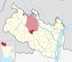
Saidpur
সৈয়দপুর | |
|---|---|
| Sayedpur | |
 Chini Mosque, Saidpur | |
 | |
| Coordinates: 25°46.7′N 88°53.5′E / 25.7783°N 88.8917°E | |
| Country | |
| Division | Rangpur |
| District | Nilphamari |
| Headquarters | Saidpur |
| Area | |
• Upazila | 121.66 km2 (46.97 sq mi) |
| • Urban | 34.82 km2 (13.44 sq mi) |
| [1] | |
| Elevation | 36 m (118 ft) |
| Population | |
• Upazila | 312,993 |
| • Density | 2,600/km2 (6,700/sq mi) |
| Time zone | UTC+6 (BST) |
| Postal code | 5310[4] |
| Area code | 05526[5] |
| Website | Syedpur Upazila |
Saidpur (Bengali: সৈয়দপুর) is an upazila of Nilphamari District in the Division of Rangpur, Bangladesh. Saidpur thana, later turned into an upazila, was established in 1915.[1] Before 1870, Saidpur was a Bazar under Daroani thana of Rangpur district. It was under Nilphamari Sadar thana of Nilphamari Mohokuma between 1870 and 1915.
- ^ a b "Municipality at a glance - Syedpur Upazila". Bangladesh National Portal (in Bengali). December 2020. Retrieved 1 January 2021.
- ^ "Elevation of Saidpur,Bangladesh Elevation Map, Topography, Contour". Retrieved 1 January 2021.
- ^ National Report (PDF). Population and Housing Census 2022. Vol. 1. Dhaka: Bangladesh Bureau of Statistics. November 2023. p. 403. ISBN 978-9844752016.
- ^ "Bangladesh Postal Code". Dhaka: Bangladesh Postal Department under the Department of Posts and Telecommunications of the Ministry of Posts, Telecommunications and Information Technology of the People's Republic of Bangladesh. 21 October 2024.
- ^ "Bangladesh Area Code". China: Chahaoba.com. 18 October 2024.