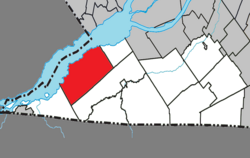
Saint-Anicet | |
|---|---|
 | |
 Location within Le Haut-Saint-Laurent RCM | |
| Coordinates: 45°07′N 74°21′W / 45.12°N 74.35°W[1] | |
| Country | Canada |
| Province | Quebec |
| Region | Montérégie |
| RCM | Le Haut-Saint-Laurent |
| Constituted | July 1, 1855 |
| Government | |
| • Mayor | Gino Moretti |
| • Federal riding | Salaberry—Suroît |
| • Prov. riding | Huntingdon |
| Area | |
• Total | 179.52 km2 (69.31 sq mi) |
| • Land | 135.03 km2 (52.14 sq mi) |
| Population (2021)[4] | |
• Total | 2,754 |
| • Density | 20.4/km2 (53/sq mi) |
| • Pop (2016-21) | |
| • Dwellings | 1,913 |
| Time zone | UTC−5 (EST) |
| • Summer (DST) | UTC−4 (EDT) |
| Postal code(s) | |
| Area code(s) | 450 and 579 |
| Highways | |
| Website | www |
Saint-Anicet is a municipality in Le Haut-Saint-Laurent Regional County Municipality in the Montérégie administrative region of Quebec. The population as of the Canada 2021 Census was 2,754.
- ^ Cite error: The named reference
toponymiewas invoked but never defined (see the help page). - ^ a b "Répertoire des municipalités: Saint-Anicet". www.mamh.gouv.qc.ca (in French). Ministère des Affaires municipales et de l'Habitation. Retrieved 10 October 2023.
- ^ Riding history for Beauharnois—Salaberry, Quebec from the Library of Parliament
- ^ a b Cite error: The named reference
sc2021was invoked but never defined (see the help page).
