Saint-Bruno-de-Montarville | |
|---|---|
 Downtown Saint-Bruno-de-Montarville | |
| Motto(s): Fiers de nos traditions (French for "Proud of our traditions") | |
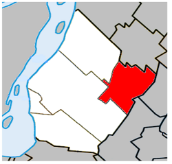
 Location within the urban agglomeration of Longueuil | |
| Coordinates: 45°32′N 73°21′W / 45.533°N 73.350°W[1] | |
| Country | |
| Province | |
| Region | Montérégie |
| RCM | None |
| Agglomeration | Longueuil |
| Founded | 1842 |
| Constituted | 1 January 2006 |
| Government | |
| • Mayor | Ludovic Grisé Farand |
| • MP | Stéphane Bergeron (BQ) |
| • MNA | Nathalie Roy (CAQ) |
| Area | |
• Total | 43.30 km2 (16.72 sq mi) |
| • Land | 42.85 km2 (16.54 sq mi) |
| Population (2021)[4] | |
• Total | 26,273 |
| • Density | 613.2/km2 (1,588/sq mi) |
| • Pop 2016-2021 | |
| • Dwellings | 10,629 |
| Demonym(s) | Montarvillois,(e) (French) |
| Time zone | UTC−5 (EST) |
| • Summer (DST) | UTC−4 (EDT) |
| Area code(s) | 450 and 579 |
| Highways | |
| Website | www |
Saint-Bruno-de-Montarville is an off-island suburb of Montreal, in southwestern Quebec, Canada, on the south bank of the Saint Lawrence River just east of Montreal. It lies on the west flank of Mont Saint-Bruno, one of the Monteregian Hills. The population as of the Canada 2021 Census was 26,273.[4]
The city is well known to Montrealers and its neighbouring population for Mont Saint-Bruno, location to both Mont-Saint-Bruno National Park and Ski Mont Saint-Bruno, a ski facility and school.
There are two prevailing hypotheses on the origin of the city's name:
- That the city was named after Bruno of Cologne and the Montarville seigneury. The name "Montarville" is a homonym of a village of Eure-et-Loir in France: Montharville, whose etymology is uncertain. The name was written in its Latin form, Mons Harvilla in the 12th century[5] – in other words "Haric's farm's mount", a name of Germanic origins also found in Harville (Hairici villa, 9th century). However, this uncommon composition of a Roman appellation ("mont") associated with the Norman toponymy "-ville" place name casts doubts on this explication. It could be the name of an unidentified Germanic individual.
- Quebec's toponymy commission suggests another hypothesis to explain the origin of the city's name. "Montarville" could be a portmanteau of "montagne" (French for mountain) and "Boucherville" after Pierre Boucher de Boucherville, the region's first seigneur. The hypothesis rests on the fact that the descendants of de Boucherville were named Montarville, Niverville, etc. The patron saint of the city could be explained by the sale of the seigneury to François-Pierre Bruneau, whose name was slightly transformed.[1]
- ^ a b Commission de toponymie du Québec. "Fiche descriptive — Saint-Bruno-de-Montarville". Government of Québec. Retrieved 23 December 2010.
- ^ a b Ministère des Affaires municipales, des Régions et de l'Occupation du territoire: Saint-Bruno-de-Montarville
- ^ Parliament of Canada Federal Riding History: SAINT-BRUNO--SAINT-HUBERT (Quebec)
- ^ a b c "Census Profile — Saint-Bruno-de-Montarville, Ville". Canada 2021 Census. Statistics Canada. 15 November 2023. Retrieved 5 May 2024.
- ^ Alfred Dauzat et Ch. Rostaing, Dictionnaire étymologique des noms de lieux en France, Librairie Guénégaud 1978.

