Saint-Flavien | |
|---|---|
 | |
| Motto(s): Générosité et Solidarité (French) "Generosity and Solidarity" | |
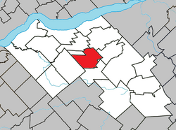
 Location within Lotbinière RCM | |
| Coordinates: 46°31′N 71°36′W / 46.517°N 71.600°W[1] | |
| Country | Canada |
| Province | Quebec |
| Region | Chaudière-Appalaches |
| RCM | Lotbinière |
| Constituted | December 29, 1999 |
| Government | |
| • Mayor | Normand Côté |
| • Federal riding | Lévis—Lotbinière |
| • Prov. riding | Lotbinière-Frontenac |
| Area | |
| • Total | 65.80 km2 (25.41 sq mi) |
| • Land | 66.16 km2 (25.54 sq mi) |
| There is an apparent contradiction between two authoritative sources | |
| Population | |
| • Total | 1,619 |
| • Density | 24.5/km2 (63/sq mi) |
| • Pop 2016-2021 | |
| • Dwellings | 735 |
| Time zone | UTC−5 (EST) |
| • Summer (DST) | UTC−4 (EDT) |
| Postal code(s) | |
| Area code(s) | 418 and 581 |
| Highways | |
| Website | www |
Saint-Flavien (French pronunciation: [sɛ̃ flavjɛ̃]) is a municipality in the Lotbinière Regional County Municipality in Quebec, Canada. It is part of the Chaudière-Appalaches region and had a population is 1,619 as of 2021.[4] The municipality, constituted in 1999, covers an area of 66 km2, with a population density of 25.
It is named after Archbishop Pierre-Flavien Turgeon and was created from the merger of the parish and the village of the same name.
- ^ Cite error: The named reference
toponymiewas invoked but never defined (see the help page). - ^ a b Cite error: The named reference
mamrotwas invoked but never defined (see the help page). - ^ a b Cite error: The named reference
cp2021was invoked but never defined (see the help page). - ^ Government of Canada, Statistics Canada (2022-02-09). "Profile table, Census Profile, 2021 Census of Population - Saint-Flavien, Municipalité (MÉ) [Census subdivision], Quebec". www12.statcan.gc.ca. Retrieved 2023-11-15.
