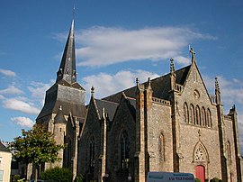
Saint-Herblain
| |
|---|---|
Commune | |
 | |
| Coordinates: 47°12′44″N 1°38′59″W / 47.2122°N 1.6497°W | |
| Country | France |
| Region | Pays de la Loire |
| Department | Loire-Atlantique |
| Arrondissement | Nantes |
| Canton | Saint-Herblain-1 and 2 |
| Intercommunality | Nantes Métropole |
| Government | |
| • Mayor (2020–2026) | Bertrand Affilé[1] |
Area 1 | 30.02 km2 (11.59 sq mi) |
| Population (2021)[2] | 49,537 |
| • Density | 1,700/km2 (4,300/sq mi) |
| Time zone | UTC+01:00 (CET) |
| • Summer (DST) | UTC+02:00 (CEST) |
| INSEE/Postal code | 44162 /44800 |
| Elevation | 1–64 m (3.3–210.0 ft) |
| 1 French Land Register data, which excludes lakes, ponds, glaciers > 1 km2 (0.386 sq mi or 247 acres) and river estuaries. | |
Saint-Herblain (French pronunciation: [sɛ̃t‿ɛʁblɛ̃] ; Gallo: Saent-Erbelaen, Breton: Sant-Ervlan, pronounced [ˈsãnt ɛrvlãn]) is a commune in the Loire-Atlantique department, administrative region of Pays de la Loire, France.[3]
It is the largest suburb of the city of Nantes, and lies adjacent to its west side.
- ^ "Répertoire national des élus: les maires" (in French). data.gouv.fr, Plateforme ouverte des données publiques françaises. 13 September 2022.
- ^ "Populations légales 2021" (in French). The National Institute of Statistics and Economic Studies. 28 December 2023.
- ^ INSEE commune file


