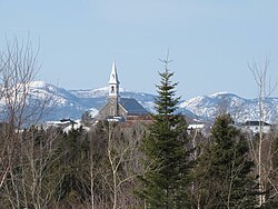
Saint-Hilarion | |
|---|---|
 Church of Saint-Hilarion overlooking the village | |
 Location within Charlevoix RCM. | |
| Coordinates: 47°34′N 70°24′W / 47.567°N 70.400°W[1] | |
| Country | |
| Province | |
| Region | Capitale-Nationale |
| RCM | Charlevoix |
| Constituted | July 1, 1855 |
| Government | |
| • Mayor | Rosaire Lavoie |
| • Federal riding | Montmorency—Charlevoix —Haute-Côte-Nord |
| • Prov. riding | Charlevoix–Côte-de-Beaupré |
| Area | |
| • Total | 101.00 km2 (39.00 sq mi) |
| • Land | 99.65 km2 (38.48 sq mi) |
| Population | |
| • Total | 1,181 |
| • Density | 11.9/km2 (31/sq mi) |
| • Pop 2006-2011 | |
| • Dwellings | 572 |
| Time zone | UTC−5 (EST) |
| • Summer (DST) | UTC−4 (EDT) |
| Postal code(s) | |
| Area code(s) | 418 and 581 |
| Highways | |
| Website | www |
Saint-Hilarion is a parish municipality in Charlevoix Regional County Municipality, in the administrative region of Capitale-Nationale of the province of Quebec, in Canada.[4]
- ^ Cite error: The named reference
toponymiewas invoked but never defined (see the help page). - ^ a b Ministère des Affaires municipales, des Régions et de l'Occupation du territoire - Répertoire des municipalités: Saint-Hilarion
- ^ a b "Saint-Hilarion census profile". Statistics Canada, 2011 Census of Population. 2007-03-13. Retrieved 2007-07-20.
- ^ Saint-Hilarion - Répertoire des municipalités du Québec
