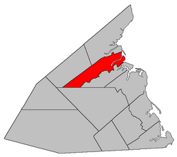
Saint-Louis
St. Louis | |
|---|---|
 Location within Kent County, New Brunswick. | |
| Coordinates: 46°43′30″N 65°04′30″W / 46.725°N 65.075°W | |
| Country | |
| Province | |
| County | Kent |
| Erected | 1855 |
| Area | |
| • Land | 258.65 km2 (99.87 sq mi) |
| Population (2021)[1] | |
| • Total | 1,760 |
| • Density | 6.8/km2 (18/sq mi) |
| • Change 2016-2021 | |
| • Dwellings | 797 |
| Time zone | UTC-4 (AST) |
| • Summer (DST) | UTC-3 (ADT) |
| Figures do not include portion within the village of Saint-Louis de Kent | |
Saint-Louis (originally Palmerston) is a geographic parish in Kent County, New Brunswick, Canada.[4]
For governance purposes it is divided between the town of Beaurivage[5] and the Kent rural district,[6] both of which are members of the Kent Regional Service Commission.[7] The rural district areas are Kouchibouguac National Park in the east and the western end of the parish.
Prior to the 2023 governance reform, the parish was divided between the local service districts of Saint-Ignace and the parish of Saint-Louis, which included an area with amended services named Canisto Road.[8]
- ^ a b "Census Profile". Statistics Canada. 26 October 2022. Retrieved 30 October 2022.
- ^ "Chapter T-3 Territorial Division Act". Government of New Brunswick. Retrieved 26 February 2023.
- ^ "Chapter I-13 Interpretation Act". Government of New Brunswick. Retrieved 26 February 2023.
- ^ The Territorial Division Act[2] divides the province into 152 parishes, the cities of Saint John and Fredericton, and one town of Grand Falls. The Interpretation Act[3] clarifies that parishes include any local government within their borders.
- ^ "Kent Regional Service Commission: RSC 6". Government of New Brunswick. Retrieved 26 February 2023.
- ^ "Kent Regional Service Commission: RD 6". Government of New Brunswick. Retrieved 26 February 2023.
- ^ "Regions Regulation – Regional Service Delivery Act". Government of New Brunswick. 21 July 2022. Retrieved 26 February 2023.
- ^ "Local Service Districts Regulation - Municipalities Act". Government of New Brunswick. 25 June 2021. Retrieved 26 February 2023.