Saint-Malo | |
|---|---|
 | |
 Location within Coaticook RCM. | |
| Coordinates: 45°12′N 71°30′W / 45.200°N 71.500°W[1] | |
| Country | |
| Province | |
| Region | Estrie |
| RCM | Coaticook |
| Constituted | January 1, 1870 |
| Government | |
| • Mayor | Jacques Madore |
| • Federal riding | Compton—Stanstead |
| • Prov. riding | Saint-François |
| Area | |
• Total | 133.10 km2 (51.39 sq mi) |
| • Land | 131.83 km2 (50.90 sq mi) |
| Population | |
• Total | 514 |
| • Density | 3.9/km2 (10/sq mi) |
| • Pop 2016-2021 | |
| • Dwellings | 265 |
| Time zone | UTC−5 (EST) |
| • Summer (DST) | UTC−4 (EDT) |
| Postal code(s) | |
| Area code | 819 |
| Highways | |
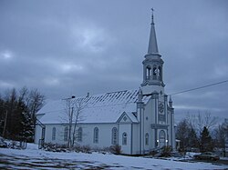
Saint-Malo () is a municipality in Quebec, Canada, on the Canada–United States border. Saint-Malo has the highest elevation of any municipality in Quebec. At 640 metres (2,100 ft), local residents live in an environment of forests, farms, and waterways that supply their livelihood.
Every September, Saint-Malo holds a Harvest Festival that includes a "country" mass. A popular point of interest is La Montagnaise, a 10 metres (33 ft)-tall observation tower built in 1995, that offers panoramic views of the countryside.
