This article needs additional citations for verification. (August 2021) |
Saint-Quentin | |
|---|---|
 | |
| Nickname: The maple syrup capital of Atlantic Canada | |
| Coordinates: 47°30′42″N 67°23′25″W / 47.51175°N 67.39014°W | |
| Country | Canada |
| Province | New Brunswick |
| County | Restigouche |
| Parish | Saint-Quentin |
| Founded | 1910 |
| Local improvement district | 1947 |
| Village | 1966 |
| Town | 1996 |
| Electoral Districts Federal | Madawaska—Restigouche |
| Provincial | Restigouche West |
| Government | |
| • Type | Saint-Quentin Town Council |
| • Mayor | Nicole Somers |
| • Deputy Mayor | Jocelyne Querry Bossé |
| • Councillors | List of Members
|
| Area | |
| • Total | 4.24 km2 (1.64 sq mi) |
| Elevation | 283 m (928 ft) |
| Population (2021)[2] | |
| • Total | 2,141 |
| • Density | 504.7/km2 (1,307/sq mi) |
| • Change (2016–21) | |
| • Dwellings | 1,015 |
| Time zone | UTC-4 (AST) |
| • Summer (DST) | UTC-3 (ADT) |
| Postal code(s) | |
| Area code | 506 |
| Highways | |
| NTS Map | 021O11 |
| GNBC Code | DAEGG |
| Website | saintquentin.nb.ca |
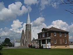
Saint-Quentin is a town in northern New Brunswick, Canada.[1]
Saint-Quentin is in the Restigouche region of the Appalachian Mountains, 50 kilometres west of Mount Carleton, the province's highest elevation.
The great majority of individuals in the area speak French.
On 1 January 2023, Saint-Quentin annexed the local service district (LSD) of St. Martin de Restigouche and part of the LSD of the parish of Saint-Quentin[3][4] Revised census figures have not been released.
- ^ a b "Community Profile - Saint-Quentin". Government of New Brunswick. Retrieved August 13, 2019.
- ^ a b "Census Profile of Saint-Quentin, Town (TV)". Statistics Canada. 6 December 2022. Retrieved 21 January 2023.
- ^ "Local Governments Establishment Regulation – Local Governance Act". Government of New Brunswick. 12 October 2022. Retrieved 21 January 2023.
- ^ "RSC 1 Northwest Regional Service Commission". Government of New Brunswick. Retrieved 21 January 2023.

