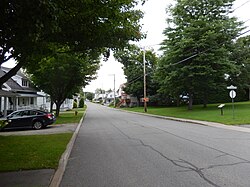
Saint-Ubalde | |
|---|---|
 | |
 Location within Portneuf RCM | |
| Coordinates: 46°45′N 72°16′W / 46.750°N 72.267°W[1] | |
| Country | |
| Province | |
| Region | Capitale-Nationale |
| RCM | Portneuf |
| Settled | 1860 |
| Constituted | March 3, 1973 |
| Government | |
| • Mayor | Pierre Saint-Germain |
| • Federal riding | Portneuf—Jacques-Cartier |
| • Prov. riding | Portneuf |
| Area | |
• Total | 146.40 km2 (56.53 sq mi) |
| • Land | 140.21 km2 (54.14 sq mi) |
| Population (2011)[3] | |
• Total | 1,403 |
| • Density | 10.0/km2 (26/sq mi) |
| • Pop 2006-2011 | |
| • Dwellings | 1,015 |
| Time zone | UTC−5 (EST) |
| • Summer (DST) | UTC−4 (EDT) |
| Postal code(s) | |
| Area code(s) | 418 and 581 |
| Highways | |
| Website | saintubalde |
Saint-Ubalde is a rural municipality in Portneuf County in the Canadian province of Quebec.
Geographically its territory is marked by an agricultural and populated area in the south-west, and an undeveloped hilly area in the north-east.
Numerous watercourses and lakes (Blanc, Sainte-Anne, Ricard, Thom) crisscross and dot is entire territory.
The inhabited section is located in the southeast. Saint-Ubalde is centred on potato cultivation and outdoor recreation (canoeing, water skiing, fishing).[1]'.[4]
- ^ a b Cite error: The named reference
toponymiewas invoked but never defined (see the help page). - ^ a b Ministère des Affaires municipales, des Régions et de l'Occupation du territoire - Répertoire des municipalités: Saint-Ubalde Archived 2015-12-09 at the Wayback Machine
- ^ a b Statistics Canada 2011 Census - Saint-Ubalde census profile
- ^ Stéfanos (2012-07-30). "Hydrological and multi-resource portrait of the Sainte-Anne River watershed" (PDF) (in French). CAPSA. pp. 27/137. Retrieved 2023-11-01.

