| Saint Elias Mountains | |
|---|---|
 | |
| Highest point | |
| Peak | Mount Logan |
| Elevation | 5,959 m (19,551 ft)[1] |
| Listing | List of mountain ranges |
| Coordinates | 60°34′02″N 140°24′19″W / 60.56722°N 140.40528°W[2] |
| Dimensions | |
| Length | 300 mi (480 km) |
| Width | 90 mi (140 km) |
| Area | 112,509 km2 (43,440 sq mi) |
| Geography | |
| Countries |
|
| Provinces | |
| State | Alaska |
| Range coordinates | 60°30′N 139°30′W / 60.500°N 139.500°W |
| Parent range | Pacific Coast Ranges |
| Borders on | Wrangell Mountains |
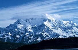
The Saint Elias Mountains (French: Chaîne Saint-Élie) are a subgroup of the Pacific Coast Ranges, located in southeastern Alaska in the United States, Southwestern Yukon and the very far northwestern part of British Columbia in Canada. The range spans Wrangell-St. Elias National Park and Preserve in the United States and Kluane National Park and Reserve in Canada and includes all of Glacier Bay National Park in Alaska. In Alaska, the range includes parts of the city/borough of Yakutat and the Hoonah-Angoon and Valdez-Cordova census areas.[3]
This mountain range is named after Mount Saint Elias, which in turn was named in 1741 by the Danish-born Russian explorer Vitus Bering.[4]
- ^ "Topographic map of Mount Logan". opentopomap.org. Retrieved 2023-05-28.
- ^ "Mount Logan". Geographical Names Data Base. Natural Resources Canada. Retrieved 2023-05-28.
- ^ "Saint Elias Mountains". Geographic Names Information System. United States Geological Survey, United States Department of the Interior. Retrieved 2007-12-03.
- ^ "Saint. Elias Mountains". BC Geographical Names. Retrieved 2013-12-27.
