| Saint Mary's Wilderness | |
|---|---|
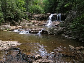
 Saint Mary's Falls | |
| Location | Augusta, Virginia, United States |
| Coordinates | 37°55′29″N 79°08′07″W / 37.92472°N 79.13528°W |
| Area | 9,826 acres (39.76 km2)[1] |
| Elevation | 3,400 ft (1,000 m) |
| Established | 1984 |
| Operator | George Washington and Jefferson National Forests |
| Website | George Washington and Jefferson National Forests - Saint Mary's Wilderness Area |
Saint Mary's Wilderness is a U.S. Wilderness Area in the George Washington and Jefferson National Forests. The wilderness area is located next to the Blue Ridge Parkway near the Parkway's northern terminus and consists of 9,826 acres (39.76 km2). Saint Mary's Wilderness is the largest Virginia Wilderness on national forest land.[2] Saint Mary's Wilderness ranges in elevation from about 1,780 feet (543 m) to 3,640 feet (1,109 m). The area has about 14 miles (23 km) of hiking trails within or near its boundaries.
Saint Mary's Wilderness includes the drainages of Cellar Hollow, Spy Run, and the upper part of the Saint Mary's River. Each waterway is a tributary of the South River; via the Maury and James rivers, which are part of the Chesapeake Bay watershed.
- ^ "Wilderness.net - Acreage Breakdown". Wilderness.net. Retrieved 14 March 2018.
- ^ "George Washington and Jefferson National Forests - Saint Mary's Wilderness". Retrieved 14 March 2018.
