Parish of Saint Mary[1] | |
|---|---|
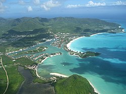
(from top: left to right) Jolly Harbour, Valley Church Beach, the Shekerley Mountains near John Hughes, Hermitage Bay | |
![Location of Parish of Saint Mary[1]](http://upload.wikimedia.org/wikipedia/commons/thumb/c/cc/Saint_Mary_in_Antigua_and_Barbuda_%28cropped%29.svg/250px-Saint_Mary_in_Antigua_and_Barbuda_%28cropped%29.svg.png) | |
| Country | Antigua and Barbuda |
| Established | January 11, 1692 (old style) January 21, 1692 (new style) |
| Capital | Old Road |
| Largest city | Bolans |
| Government | |
| • MPs | Molwyn Joseph, Kelvin Simon, Jamale Pringle, Anthony Smith |
| Population (2018) | |
• Total | 8,141[2] |
| Time zone | UTC-4 (AST) |
Saint Mary, officially the Parish of Saint Mary, is a parish of Antigua and Barbuda on the island of Antigua. Saint Mary borders Saint John to the north, and Saint Paul to the east. Saint Mary is dominated by the Shekerley Mountains, and its northern border is largely defined by the mountains, and by Cooks Creek. The largest city in the parish is Bolans, home to the Jolly Harbour neighbourhood, and the parish church is located in Old Road. Saint Mary was permanently established with the other four original parishes in 1692.[3] It had an estimated population of 8,141 in 2018.[4]
The only area in which the Antigua black pineapple can be produced is the Pineapple Belt, which includes Saint Mary. The settlements of Old Road and Urlings are located in the southern part of the parish, and Bolans and Jennings are located in the flat northern half of the parish, where the majority of Saint Mary's population is concentrated. The Shekerley Mountains shield most of the parish's land area from human population, leaving the remaining portion of the parish largely uninhabited. The remote community of John Hughes, which has less ties to the parish as a whole than to Swetes in Saint Paul, is one of the few settlements found inside the Sherkerley Mountains.
Saint Mary was created in August 1681, when Antigua was divided into five parishes.[3] Saint Mary and the four other parishes were permanently established in July 1692, and confirmed in January 1693.[3] The primary objective of the establishment of parishes was providing for the parish church. The majority of the parish's agricultural lands, with the exception of the mountains, were formerly home to sugar mills. Numerous historical relics from the parish can still be seen today, including the Yorke's[5] and Sawcolt's plantations.[6]
- ^ http://laws.gov.ag/wp-content/uploads/2018/08/cap-304.pdf [bare URL PDF]
- ^ "Antigua and Barbuda 2018 Labour Force Survey Report" (PDF). statistics.gov.ag. Statistics Division, Ministry of Finance and Corporate Governance, Antigua and Barbuda. October 2020.
- ^ a b c The Laws of the Island of Antigua: Consisting of the Acts of the Leeward Islands, Commencing 8th November 1690, Ending 21st April 1798; and the Acts of Antigua, Commencing 10th April 1668, Ending 7th May 1804. Strand, London: Samuel Bagster. 1805.
- ^ "Antigua and Barbuda 2018 Labour Force Survey Report" (PDF). statistics.gov.ag. Statistics Division, Ministry of Finance and Corporate Governance, Antigua and Barbuda. October 2020.
- ^ "Yorke's – Antigua Sugar Mills". Retrieved 2023-10-14.
- ^ "Sawcolt's – Antigua Sugar Mills". Retrieved 2023-10-14.


