| Sainte-Anne-de-Bellevue Canal Canal de Sainte-Anne-de-Bellevue | |
|---|---|
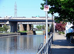
 The Sainte-Anne-de-Bellevue Canal and boardwalk | |
| Location | Quebec, Canada |
| Nearest city | Sainte-Anne-de-Bellevue |
| Coordinates | 45°24′13″N 73°57′16″W / 45.40361°N 73.95444°W |
| Area | 1.6 hectares (4.0 acres) |
| Established | 1972 |
| Built | 1843 |
| Visitors | 181,000[1] (in 2003) |
| Governing body | Parks Canada |
| Website | Official website |
The Sainte-Anne-de-Bellevue Canal is a canal and set of locks linking Lake Saint-Louis and Lake of Two Mountains at Sainte-Anne-de-Bellevue, the very westernmost point of Montreal Island, Quebec, Canada. It is a National Historic Site of Canada.
The canal is located in the eastern channel of the Ottawa River around Perrot Island (Île Perrot) where shallow rapids form a natural obstacle. It forms part of the waterway system that allows boating access from the Saint Lawrence River up the Ottawa River to the City of Ottawa, and even to Lake Ontario via the Rideau Canal.
The canal and locks are used today exclusively for recreational boating. The site is a popular tourist location that also offers mooring places, picnic tables, boat launch, and park land. Guided tours and interpretative panels are provided by Parks Canada. Together with the boardwalk and restaurants and cafes that line the canal, the site drew 181,000 visitors and 23,000 boaters in 2003, making it the second busiest canal and locks in Quebec.[1] The dimensions of the lock are 54.86 metres (180.0 ft) long, 12.19 metres (40.0 ft) wide, and 2.74 metres (9.0 ft) deep at the sills. It lifts boats by 1 metre (3.3 ft).[2][3]
- ^ a b "Visitation". Saint-Anne-de-Bellevue Canal National Historic Site of Canada Management Plan. Parks Canada. May 2005. Retrieved 2010-06-10.
- ^ Sainte-Anne-de-Bellevue Canal National Historic Site - Visitor Information: Technical Fact Sheet
- ^ "Saint-Anne-de-Bellevue Canal National Historic Site of Canada Management Plan". Parks Canada. May 2005. Retrieved 2010-06-10.