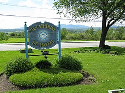
Sainte-Catherine-de-Hatley | |
|---|---|
 Entrance of Sainte-Catherine-de-Hatley | |
 Location within Memphrémagog RCM | |
| Coordinates: 45°15′N 72°03′W / 45.25°N 72.05°W[1] | |
| Country | Canada |
| Province | Quebec |
| Region | Estrie |
| RCM | Memphrémagog |
| Constituted | March 28, 1901 |
| Government | |
| • Mayor | Jacques Demers |
| • Federal riding | Compton—Stanstead |
| • Prov. riding | Orford |
| Area | |
| • Total | 99.20 km2 (38.30 sq mi) |
| • Land | 86.34 km2 (33.34 sq mi) |
| Population (2021)[4] | |
| • Total | 2,741 |
| • Density | 31.7/km2 (82/sq mi) |
| • Pop 2016-2021 | |
| • Dwellings | 1,429 |
| Time zone | UTC−5 (EST) |
| • Summer (DST) | UTC−4 (EDT) |
| Postal code(s) | |
| Area code | 819 |
| Highways | |
| Website | www |
Sainte-Catherine-de-Hatley is a municipality in the Memphrémagog Regional County Municipality in the Eastern Townships region of Quebec, Canada.
Located along Quebec Route 108 on Little Lake Magog, it is the home of the "Marais" birdwatching sanctuary, the Eglise Sainte Catherine de Hatley, as well as the Dominique Savio primary School.[citation needed]
The place was previously known as "Katevale".
"Originally, a mission was established in 1845 under the name of Sainte-Catherine-de-Hatley and was canonically erected in 1890. Subsequently, a municipality of the same name was created in 1901".[5]
- ^ Cite error: The named reference
toponymiewas invoked but never defined (see the help page). - ^ a b Ministère des Affaires municipales, des Régions et de l'Occupation du territoire: Sainte-Catherine-de-Hatley
- ^ Parliament of Canada Federal Riding History: COMPTON--STANSTEAD (Quebec)
- ^ a b 2021 Statistics Canada Census Profile: Sainte-Catherine-de-Hatley, Quebec
- ^ Toponymy: Sainte-Catherine-de-Hatley
