Sainte-Marie | |
|---|---|
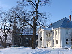
 Taschereau Mansion and Sainte-Anne Chapel | |
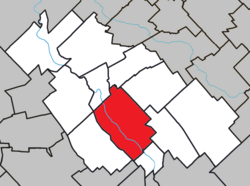
 Location within La Nouvelle-Beauce RCM | |
| Coordinates: 46°27′N 71°02′W / 46.450°N 71.033°W[1] | |
| Country | Canada |
| Province | Quebec |
| Region | Chaudière-Appalaches |
| RCM | La Nouvelle-Beauce |
| Constituted | April 15, 1978 |
| Government | |
| • Mayor | Gaétan Vachon |
| • Federal riding | Beauce |
| • Prov. riding | Beauce-Nord |
| Area | |
| • Total | 108.90 km2 (42.05 sq mi) |
| • Land | 107.55 km2 (41.53 sq mi) |
| Population (2021)[3] | |
| • Total | 13,134 |
| • Density | 122.1/km2 (316/sq mi) |
| • Pop 2016-2021 | |
| • Dwellings | 5,630 |
| Demonym(s) | Mariverains, Mariveraines |
| Time zone | UTC−5 (EST) |
| • Summer (DST) | UTC−4 (EDT) |
| Postal code(s) | |
| Area code(s) | 418 and 581 |
| Highways | |
| Website | www |
Sainte-Marie is a city in the province of Quebec, Canada. It is the seat of La Nouvelle-Beauce Regional County Municipality, in Chaudière-Appalaches, Quebec, Canada. It had a population was 13,134 as of the Canada 2021 Census, when 95.7% was French-speaking. It is located 59 kilometres (37 mi) south-east of Quebec City, on the Chaudière River.

