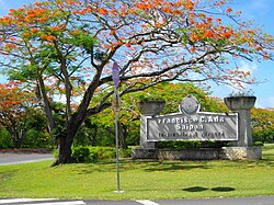
Saipan International Airport Francisco C. Ada Airport | |||||||||||||||
|---|---|---|---|---|---|---|---|---|---|---|---|---|---|---|---|
 | |||||||||||||||
| Summary | |||||||||||||||
| Airport type | Public | ||||||||||||||
| Owner | Commonwealth Ports Authority | ||||||||||||||
| Location | Saipan, Northern Mariana Islands | ||||||||||||||
| Elevation AMSL | 215 ft / 66 m | ||||||||||||||
| Coordinates | 15°07′08″N 145°43′46″E / 15.11889°N 145.72944°E | ||||||||||||||
| Website | cpa | ||||||||||||||
| Map | |||||||||||||||
| Runways | |||||||||||||||
| |||||||||||||||
| Statistics (2022) | |||||||||||||||
| |||||||||||||||

Saipan International Airport (IATA: SPN, ICAO: PGSN, FAA LID: GSN), also known as Francisco C. Ada/Saipan International Airport, is a public airport located on Saipan Island in the United States Commonwealth of the Northern Mariana Islands. The airport is owned by Commonwealth Ports Authority.[1] Its airfield was previously known as Aslito (during the Japanese South Seas Mandate) and Isely Field (during the American World War II and later period).
This airport is assigned a three-letter location identifier of GSN by the Federal Aviation Administration, but the International Air Transport Association (IATA) airport code is SPN (the IATA assigned GSN to Mount Gunson Airport in Australia).[1][2][3][4]
- ^ a b c FAA Airport Form 5010 for GSN PDF, retrieved 2021-06-09
- ^ "Airline and Airport Code Search". International Air Transport Association (IATA). Retrieved November 14, 2016.
- ^ "Saipan International (IATA: SPN, ICAO: PGSN, FAA: GSN)". Great Circle Mapper. Retrieved November 14, 2016.
- ^ "Mount Gunson Airport (IATA: GSN, ICAO: YMGN)". Aviation Safety Network. Retrieved November 14, 2016.
