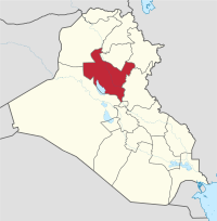
Saladin Governorate
صلاح الدين | |
|---|---|
| Ṣalāḥ al-Dīn | |
 | |
| Coordinates: 34°27′N 43°35′E / 34.450°N 43.583°E | |
| Country | Iraq |
| Capital | Tikrit |
| Governor | Badir al-Fahl |
| Area | |
• Total | 24,751 km2 (9,556 sq mi) |
| Population (2018) | |
• Total | 1,595,235 |
| Official language(s) | Arabic |
| HDI (2021) | 0.692[1] medium |
The Saladin, Salah ad Din, or Salah Al-Din Governorate (Arabic: محافظة صلاح الدين, Muḥāfaẓat Ṣalāḥ al-Dīn) is one of Iraq's 19 governorates, north of Baghdad. It has an area of 24,363 square kilometres (9,407 sq mi), with an estimated population of 1,042,200 people in 2003. It is made up of 8 districts, with the capital being Tikrit. Before 1976 the governorate was part of Baghdad Governorate.
The governorate is named after the Kurdish Muslim leader Saladin or Salah ad Din, who hailed from the governorate. This Sunni-dominated governorate is also known as the home of Saddam Hussein, who hailed from the village of Al-Awja. Salah Al-Din governorate, a traditional stronghold of Saddam and his Al-Bu Nasir tribe that is located in the heart of the Sunni Triangle, has been rocked by insurgencies, sectarian violence and tribal rivalries ever since Coalition forces invaded Iraq in 2003.[2]
- ^ "Sub-national HDI - Area Database - Global Data Lab". hdi.globaldatalab.org. Retrieved 2018-09-13.
- ^ "Iraq: No end to violence in Saddam's home province". ReliefWeb. 24 January 2007.
