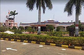
Salem Airport | |||||||||||
|---|---|---|---|---|---|---|---|---|---|---|---|
 | |||||||||||
| Summary | |||||||||||
| Airport type | Public | ||||||||||
| Owner | Ministry of Civil Aviation | ||||||||||
| Operator | Airports Authority of India | ||||||||||
| Serves | Salem Metropolitan Area | ||||||||||
| Location | Kamalapuram, Salem district, Tamil Nadu, India | ||||||||||
| Opened | 1993[1] | ||||||||||
| Elevation AMSL | 307 m / 1,008 ft | ||||||||||
| Coordinates | 11°46′55″N 078°03′52″E / 11.78194°N 78.06444°E | ||||||||||
| Website | Salem Airport | ||||||||||
| Map | |||||||||||
 | |||||||||||
| Runways | |||||||||||
| |||||||||||
| Statistics (April 2023 - March 2024) | |||||||||||
| |||||||||||
Salem Airport (IATA: SXV, ICAO: VOSM) is a domestic airport serving the city of Salem, along with neighboring cities of Erode and Karur, in Tamil Nadu, India. It is located at Kamalapuram in Omalur taluk, 19 km (12 mi) north-west from the city centre. It was the sixth-busiest airport in Tamil Nadu after Chennai, Coimbatore, Tiruchirappalli, Madurai, and Tuticorin airports. It is also the fifth-largest airport in Tamil Nadu in terms of runway length.[5][6]
- ^ Cite error: The named reference
hinwas invoked but never defined (see the help page). - ^ "Annexure III – Passenger Data" (PDF). aai.aero. Retrieved 23 April 2024.
- ^ "Annexure II – Aircraft Movement Data" (PDF). aai.aero. Retrieved 23 April 2024.
- ^ "Annexure IV – Freight Movement Data" (PDF). aai.aero. Retrieved 23 April 2024.
- ^ "Airport information for VOMM". World Aero Data. Archived from the original on 5 March 2019.
{{cite web}}: CS1 maint: unfit URL (link) Data current as of October 2006. Source: DAFIF. - ^ Airport information for MAA at Great Circle Mapper. Source: DAFIF (effective October 2006).


