Salem Maritime National Historic Site | |
 Salem Custom House (1819) | |
| Location | Essex County, Massachusetts, US |
|---|---|
| Nearest city | Salem, Massachusetts |
| Coordinates | 42°31′14″N 70°53′14″W / 42.52056°N 70.88722°W |
| Area | 9 acres (0.036 km2) |
| Visitation | 676,216 (2005) |
| Website | Salem Maritime National Historic Site |
| NRHP reference No. | 66000048 |
| Significant dates | |
| Added to NRHP | September 1, 1976 |
| Designated NHS | March 17, 1938 |
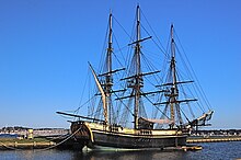
The Salem Maritime National Historic Site is a National Historic Site consisting of 12 historic structures, one replica tall-ship, and about 9 acres (36,000 m2) of land along the waterfront of Salem Harbor in Salem, Massachusetts, United States. Salem Maritime is the first National Historic Site established in the United States (March 17, 1938).[1] It interprets the Triangle Trade during the colonial period, in cotton, rum, sugar and slaves; the actions of privateers during the American Revolution; and global maritime trade with the Far East, after independence. The National Park Service manages both the National Historic Site and a Regional Visitor Center in downtown Salem. The National Park Service (NPS) is an agency of the United States Department of the Interior.
In 2014, the National Park Service, which runs the Salem Maritime National Historic Site, released figures and statistics for 2012: there were 756,038 visitors to Salem who spent an estimated $40,000,000.[2] The National Park Service celebrated its 100th anniversary in 2016.[3][4][5]

- ^ "History & Culture - Salem Maritime National Historic Site (U.S. National Park Service)". Nps.gov. Retrieved June 8, 2019.
- ^ Tom Dalton. "What's drawing the most visitors?". Salem News. Retrieved June 8, 2019.
- ^ "We're inviting you to our 100th birthday party! - Centennial (U.S. National Park Service)". Nps.gov. Retrieved June 8, 2019.
- ^ Dustin Luca. "Halloween steps off in Salem". Salem News. Retrieved June 8, 2019.
- ^ Glusac, Elaine (June 30, 2016). "Celebrating the National Park Centennial". Nytimes.com. Retrieved June 8, 2019.

