| Saline River Ne Miskua[1] | |
|---|---|
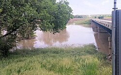
 Saline River near Russell, Kansas | |
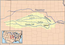
 Map of the Smoky Hill drainage basin including the Saline River | |
| Location | |
| Country | United States |
| State | Kansas |
| Physical characteristics | |
| Source confluence | |
| • location | Sheridan County, Kansas |
| • coordinates | 39°09′38″N 100°42′50″W / 39.16056°N 100.71389°W[1] |
| • elevation | 2,864 ft (873 m) |
| Mouth | Smoky Hill River |
• location | New Cambria, Kansas |
• coordinates | 38°51′28″N 97°30′22″W / 38.85778°N 97.50611°W[1] |
• elevation | 1,171 ft (357 m) |
| Length | 397 mi (639 km) |
| Basin size | 3,419 sq mi (8,860 km2) |
| Discharge | |
| • location | USGS 06869500 at Tescott, KS[2] |
| • average | 214 cu ft/s (6.1 m3/s) |
| • minimum | 0 cu ft/s (0 m3/s) |
| • maximum | 47,600 cu ft/s (1,350 m3/s) |
| Basin features | |
| Tributaries | |
| • left | North Fork Saline River |
| • right | South Fork Saline River |
| Watersheds | Saline-Smoky Hill-Kansas-Missouri-Mississippi |
The Saline River is a 397-mile-long (639 km)[3] tributary of the Smoky Hill River in the central Great Plains of North America. The entire length of the river lies in the U.S. state of Kansas in the northwest part of the state. Its name comes from the French translation of its Native name Ne Miskua, referring to its salty content.[4]
- ^ a b c U.S. Geological Survey Geographic Names Information System: Saline River
- ^ "Water-Data Report 2010 - 06869500 Saline River at Tescott, KS" (PDF). U.S. Geological Survey. Retrieved 2015-10-20.
- ^ U.S. Geological Survey. National Hydrography Dataset high-resolution flowline data. The National Map, accessed March 29, 2011
- ^ Aiken, Charles Curry (2004). The American Counties: Origins of County Names, Dates of Creation, and Population Data, 1950-2000. Lanham: Scarecrow Press. p. 266.