This article needs additional citations for verification. (May 2022) |
Salisbury, Connecticut | |
|---|---|
| Town of Salisbury | |
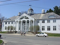
 Salisbury Town Hall | |
| Coordinates: 41°59′06″N 73°25′20″W / 41.98500°N 73.42222°W | |
| Country | |
| U.S. state | |
| County | Litchfield |
| Region | Northwest Hills |
| Established / Incorporated | 1741[1] |
| Government | |
| • Type | Selectman-town meeting |
| • First selectman | Curtis G. Rand (D) |
| • Selectman | Chris Williams (D) |
| • Selectman | Don Mayland (R) |
| Area | |
• Total | 60.1 sq mi (155.6 km2) |
| • Land | 57.3 sq mi (148.3 km2) |
| • Water | 2.8 sq mi (7.3 km2) |
| Elevation | 699 ft (213 m) |
| Population (2020) | |
• Total | 4,194 |
| • Density | 70/sq mi (27/km2) |
| Time zone | UTC-5 (Eastern) |
| • Summer (DST) | UTC-4 (Eastern) |
| ZIP codes | 06039, 06068 06079 |
| Area code(s) | 860/959 |
| FIPS code | 09-66420 |
| GNIS feature ID | 0213500 |
| Website | salisburyct |
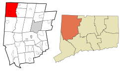
Salisbury (/ˈsɑːlzbɛri/) is a town situated in Litchfield County, Connecticut, United States. The town is the northwesternmost in the state of Connecticut; the Connecticut-Massachusetts-New York tri-state marker is located at the northwestern corner of the town. The population was 4,194 at the 2020 census.[2] The town is part of the Northwest Hills Planning Region.
- ^ Cite error: The named reference
The Town of Salisbury Connecticutwas invoked but never defined (see the help page). - ^ "Census - Geography Profile: Salisbury town, Litchfield County, Connecticut". United States Census Bureau. Retrieved December 21, 2021.


