Salmo | |
|---|---|
| The Corporation of the Village of Salmo[1] | |
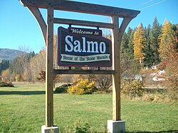
 Salmo's welcome sign | |
| Coordinates: 49°11′39″N 117°16′40″W / 49.19417°N 117.27778°W | |
| Country | Canada |
| Province | British Columbia |
| Region | West Kootenay |
| Regional district | Central Kootenay |
| Incorporated | 1946 |
| Government | |
| • Governing body | Salmo Village Council |
| Area | |
• Total | 2.44 km2 (0.94 sq mi) |
| Elevation | 670 m (2,200 ft) |
| Population (2016)[2] | |
• Total | 1,141 |
| • Density | 466.2/km2 (1,207/sq mi) |
| Time zone | UTC−08:00 (PST) |
| Area code(s) | 250, 778, 236, & 672 |
| Highways | |
| Waterways | Salmo River |
| Website | salmo |
Salmo is a village in the West Kootenay region of southeastern British Columbia. It is mostly on the north side of Erie Creek at the confluence with the Salmo River.[3] The place lies largely east of the junction of BC Highway 3 (about 42 kilometres (26 mi) southeast of Castlegar), and BC Highway 6 (about 41 kilometres (25 mi) south of Nelson, and 25 kilometres (16 mi) north of the US border).[4]
- ^ "British Columbia Regional Districts, Municipalities, Corporate Name, Date of Incorporation and Postal Address" (XLS). British Columbia Ministry of Communities, Sport and Cultural Development. Retrieved November 2, 2014.
- ^ "Census Profile, 2016 Census - Salmo, Village [Census subdivision], British Columbia and British Columbia [Province]". Statistics Canada. Government of Canada.
- ^ "Erie Creek (creek)". BC Geographical Names.
- ^ "Salmo (village)". BC Geographical Names.

