| Salmon River | |
|---|---|
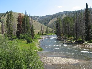
 Salmon River in Sawtooth NRA | |
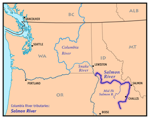
 Map of the Salmon River, showing its Middle Fork tributary and connection to the Columbia River via the Snake River | |
| Nickname(s) | River of No Return |
| Location | |
| Country | United States |
| State | Idaho |
| Cities | Salmon, Challis |
| Physical characteristics | |
| Source | Sawtooth Range |
| • location | near Norton Peak, Blaine County |
| • coordinates | 43°47′48″N 114°46′36″W / 43.79667°N 114.77667°W[1] |
| • elevation | 9,220 ft (2,810 m)[2] |
| Mouth | Snake River |
• location | west of White Bird, Idaho and Nez Perce Counties |
• coordinates | 45°51′23″N 116°47′37″W / 45.85639°N 116.79361°W[1] |
• elevation | 919 ft (280 m)[1] |
| Length | 425 mi (684 km)[3] |
| Basin size | 14,000 sq mi (36,000 km2) |
| Discharge | |
| • location | White Bird[4] |
| • average | 11,100 cu ft/s (83,000 US gal/s; 310 m3/s)[4] |
| • minimum | 1,000 cu ft/s (7,500 US gal/s; 28 m3/s) |
| • maximum | 129,000 cu ft/s (960,000 US gal/s; 3,700 m3/s) |
| Basin features | |
| Progression | Snake River → Columbia River → Pacific Ocean |
| Tributaries | |
| • left | Yankee Fork, Panther Creek, Middle Fork Salmon River, South Fork Salmon River, Little Salmon River |
| • right | East Fork Salmon River, Pahsimeroi River, Lemhi River, North Fork Salmon River |
| Type | Wild, Recreational |
| Designated | July 23, 1980 |

The Salmon River, also known as the "River of No Return", is a river located in the U.S. state of Idaho in the western United States. It flows for 425 miles (685 km) through central Idaho, draining a rugged, thinly populated watershed of 14,000 square miles (36,000 km2). The river drops more than 7,000 feet (2,100 m) from its headwaters, near Galena Summit above the Sawtooth Valley in the Sawtooth National Recreation Area, to its confluence with the Snake River. Measured at White Bird, its average discharge is 11,060 cubic feet per second (82,700 US gal/s; 313 m3/s).[5] The Salmon River is the longest undammed river in the contiguous United States.[6]
Settlements located along the Salmon River include Stanley, Clayton, Challis, Salmon, Riggins, and White Bird. Redfish Lake and Little Redfish Lake, which flow into the river via Redfish Lake Creek, are the termini of the longest Pacific sockeye salmon migration in North America.[7] The lower half of the river provides the time zone boundary for the state, with northern Idaho on Pacific Time and the rest of the state on Mountain Time.
- ^ a b c "Salmon River". Geographic Names Information System. United States Geological Survey, United States Department of the Interior. 1979-06-21. Retrieved 2013-12-14.
- ^ Google Earth elevation for GNIS source coordinates.
- ^ Salmon River Archived 2007-10-12 at the Wayback Machine, The Columbia Gazetteer of North America
- ^ a b "USGS Gage #13317000 on the Salmon River at White Bird, ID" (PDF). National Water Information System. United States Geological Survey. 1910–2012. Retrieved 2013-12-15.
- ^ USGS. "USGS Water-Data Report ID-05-1". U.S. Geological Survey Publications Warehouse. Retrieved 2020-12-07.
- ^ Palmer, Tim (1996). America by rivers. Washington, D.C. ISBN 1559632631.
{{cite book}}: CS1 maint: location missing publisher (link) - ^ "Redfish Lake sockeye salmon captive broodstock". Northwest Fisheries Science Center. National Oceanic and Atmospheric Administration. Retrieved 2013-12-14.