| Sam A. Baker State Park | |
|---|---|
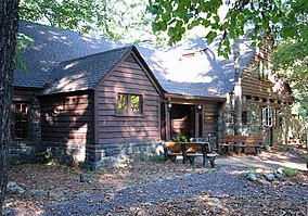
 Dining lodge made of native stone and wood | |
| Location | Wayne County, Missouri, United States |
| Coordinates | 37°15′12″N 90°31′34″W / 37.25333°N 90.52611°W[1] |
| Area | 5,323.62 acres (21.5439 km2)[2] |
| Elevation | 922 ft (281 m)[1] |
| Established | 1926 |
| Visitors | 1,103,364 (in 2022)[3] |
| Operator | Missouri Department of Natural Resources |
| Website | Sam A. Baker State Park |
Sam A. Baker State Park Historic District | |
| Nearest city | Patterson, Missouri |
| Area | 4,860 acres (1,970 ha) |
| Built | 1933 |
| Built by | Civilian Conservation Corps; Works Progress Administration |
| Architectural style | Rustic |
| MPS | ECW Architecture in Missouri State Parks 1933-1942 TR |
| NRHP reference No. | 85000540 |
| Added to NRHP | February 27, 1985 |
Sam A. Baker State Park is a public recreation area encompassing 5,323 acres (2,154 ha) in the Saint Francois Mountains region of the Missouri Ozarks. The state park offers fishing, canoeing, swimming, camping, and trails for hiking and horseback riding.[4] The visitor and nature center is housed in a historic building that was originally constructed as a stable in 1934.[5]
- ^ a b "Sam A Baker State Park". Geographic Names Information System. United States Geological Survey, United States Department of the Interior.
- ^ Cite error: The named reference
parkdatawas invoked but never defined (see the help page). - ^ "Missouri State Park Attendance For January - December, 2022" (PDF). Missouri State Parks. February 3, 2023.
- ^ Cite error: The named reference
parkswas invoked but never defined (see the help page). - ^ Cite error: The named reference
parks2was invoked but never defined (see the help page).

