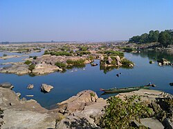
Sambalpur district | |
|---|---|
 Location in Odisha | |
| Coordinates: 21°27′58″N 83°58′59″E / 21.466°N 83.983°E | |
| Country | |
| State | |
| Headquarters | Sambalpur |
| Government | |
| • Collector & District Magistrate | Siddheshwar Baliram Bondar, IAS[1] |
| • Divisional Forest Officer Cum Wildlife Warden | Sanjeet Kumar, IFS |
| • Superintendent of Police | Kanwar Vishal Singh, IPS |
| Area | |
• Total | 6,702 km2 (2,588 sq mi) |
| Population (2011) | |
• Total | 1,041,099 |
| • Density | 122/km2 (320/sq mi) |
| Languages | |
| • Official | Odia, English |
| • Local | Sambalpuri, Kurukh, Munda, Kharia |
| Time zone | UTC+5:30 (IST) |
| PIN | 768 xxx |
| Telephone code | 663 |
| Vehicle registration | OD-15, OR-15(till 2012) |
| Sex ratio | 1.031 ♂/♀ |
| Literacy | 67.25% |
| Lok Sabha constituency | Sambalpur |
| Vidhan Sabha constituency | 4
|
| Website | www |
| This article is part of a series on |
| Odisha |
|---|
 |
| Governance |
| Topics |
|
Districts Divisions |
| GI Products |
|
|
Sambalpur District is a district in the western part of state of Odisha, India. The historic city of Sambalpur is the district headquarters.
The district is located in the Mahanadi River basin. It has a total area of 6,702 km2 (2,588 sq mi), of which almost 60% of the district is covered in dense forest. The district is bounded by Deogarh District to the east, Bargarh and Jharsuguda districts to the west, Sundergarh District to the north, and Subarnapur and Angul districts in the south.
Sambalpur City is the connecting city between Chhattisgarh and Odisha. Whereas it used to be known for its importance as a diamond trading centre, nowadays it is mainly known for its textiles, especially the Sambalpuri Saree.
- ^ "Odisha Govt effects major IAS reshuffle: Siddheshwar Baliram Bondar appointed Sambalpur Collector". New India Express News. 8 August 2024. Retrieved 8 August 2022.


