You can help expand this article with text translated from the corresponding article in German. (September 2022) Click [show] for important translation instructions.
|
You can help expand this article with text translated from the corresponding article in Alemannic. (September 2022) Click [show] for important translation instructions.
|
Samnaun | |
|---|---|
 | |
| Coordinates: 46°56′N 10°21′E / 46.933°N 10.350°E | |
| Country | Switzerland |
| Canton | Grisons |
| District | Engiadina Bassa/Val Müstair |
| Area | |
| • Total | 56.18 km2 (21.69 sq mi) |
| Elevation (Church) | 1,844 m (6,050 ft) |
| Population (31 December 2018)[2] | |
| • Total | 767 |
| • Density | 14/km2 (35/sq mi) |
| Time zone | UTC+01:00 (Central European Time) |
| • Summer (DST) | UTC+02:00 (Central European Summer Time) |
| Postal code(s) | 7562-63 |
| SFOS number | 3752 |
| ISO 3166 code | CH-GR |
| Localities | Compatsch, Laret, Plan, Ravaisch and Samnaun |
| Surrounded by | Ischgl (AT-7), Kappl (AT-7), Ramosch, See (AT-7), Spiss (AT-7), Valsot |
| Website | www SFSO statistics |
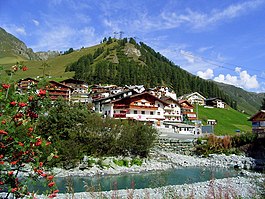
Samnaun (Romansh: Samignun) is a high Alpine village and a valley at the eastern end of Switzerland and a municipality in the Engiadina Bassa/Val Müstair Region in the Swiss canton of Graubünden.
- ^ a b "Arealstatistik Standard - Gemeinden nach 4 Hauptbereichen". Federal Statistical Office. Retrieved 13 January 2019.
- ^ "Ständige Wohnbevölkerung nach Staatsangehörigkeitskategorie Geschlecht und Gemeinde; Provisorische Jahresergebnisse; 2018". Federal Statistical Office. 9 April 2019. Retrieved 11 April 2019.


