This article is written like a travel guide. (February 2020) |
Samphanthawong
สัมพันธวงศ์ | |
|---|---|
| Other transcription(s) | |
| • Teochew | 三攀他翁[i] Sam-phang-tha-ong (Pe̍h-ūe-jī) Sam1pang1ta1ong1 (Peng'im) Sānpāntāwēng (Hanyu Pinyin) |
 | |
| Nickname: Chinatown | |
 District location in Bangkok | |
| Coordinates: 13°43′53″N 100°30′51″E / 13.73139°N 100.51417°E | |
| Country | Thailand |
| Province | Bangkok |
| Seat | Talat Noi |
| Khwaeng | 3 |
| Area | |
| • Total | 1.416 km2 (0.547 sq mi) |
| Population (2017) | |
| • Total | 24,150[2] |
| • Density | 17,055/km2 (44,170/sq mi) |
| Time zone | UTC+7 (ICT) |
| Postal code | 10100 |
| Geocode | 1013 |
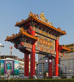
Samphanthawong (Thai: สัมพันธวงศ์, pronounced [sǎm.pʰān.tʰā.wōŋ])) is one of the 50 districts (khet) of Bangkok, Thailand. Regarded as Bangkok's Chinatown, it is the smallest district by area in Thailand. Neighboring districts are (from north clockwise) Pom Prap Sattru Phai, Bang Rak, Khlong San (across Chao Phraya River), and Phra Nakhon.
- ^ Numtong, Kanokporn (2011). ตำราการแปลภาษาไทยเป็นภาษาจีน (in Thai) (2 ed.). Bangkok: Confucius Institute at Kasetsart University. p. 42.
- ^ "Population and House Report for Year 2017". Department of Provincial Administration, Ministry of Internal Affairs. Retrieved 2018-04-01. (Search page)
Cite error: There are <ref group=lower-roman> tags or {{efn-lr}} templates on this page, but the references will not show without a {{reflist|group=lower-roman}} template or {{notelist-lr}} template (see the help page).