Bridge No. 1860 | |
 | |
| Location | Massapeag Side Rd. (Rt. 433) over Shantok Brook, Montville, Connecticut |
|---|---|
| Coordinates | 41°28′48″N 72°5′12″W / 41.48000°N 72.08667°W |
| Area | less than one acre |
| Built | 1936 |
| Architectural style | Vernacular, Rustic |
| MPS | Connecticut State Park and Forest Depression-Era Federal Work Relief Programs Structures TR |
| NRHP reference No. | 93000644[1] |
| Added to NRHP | July 29, 1993 |
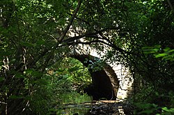
Bridge No. 1860, also known as the Samson Occom Bridge, is a fieldstone arch bridge in Montville, Connecticut, United States. Constructed by the Connecticut State Highway Department in 1936 as a Works Progress Administration project, it is located on Mohegan tribal land in an area that was once a part of Fort Shantok State Park. The bridge carries traffic from Massapeag Side Road (Special Service Road 433) over the Shantok Brook, a tributary of the Thames River. Spanning 12 feet (3.7 m) across the brook, the bridge's arch rises about 6 feet (1.8 m) above the water. According to a 2011 Connecticut Department of Transportation report, it carries 1,100 vehicles per day. Samson Occom Bridge was listed on the National Register of Historic Places in 1993.

