San Andreas, California | |
|---|---|
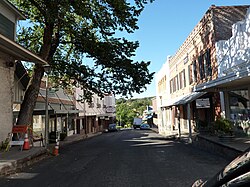
 Main Street | |
| Motto: “It’s not our fault.”[1] | |
| Coordinates: 38°11′46″N 120°40′50″W / 38.19611°N 120.68056°W | |
| Country | |
| State | |
| County | |
| Area | |
| • Total | 8.394 sq mi (21.741 km2) |
| • Land | 8.378 sq mi (21.700 km2) |
| • Water | 0.016 sq mi (0.041 km2) 0.19% |
| Elevation | 926 ft (268 m) |
| Population | |
| • Total | 2,994 |
| • Density | 360/sq mi (140/km2) |
| Time zone | UTC-8 (Pacific (PST)) |
| • Summer (DST) | UTC-7 (PDT) |
| ZIP codes | 95249-95250 |
| Area code | 209 |
| FIPS code | 06-64420 |
| GNIS feature IDs | 277590, 2409247 |
| Reference no. | 252 |
San Andreas (Californio Spanish for "St. Andrew") is an unincorporated census-designated place and the county seat of Calaveras County, California. The population was 2,783 at the 2010 census, up from 2,615 at the 2000 census. Like most towns in the region, it was founded during the California Gold Rush. The town is located on State Route 49 and is registered as California Historical Landmark #252.[5]
- ^ "Mego: Town motto can be a laughing matter, but maybe not for Naperville". Chicago Tribune.
- ^ "2010 Census U.S. Gazetteer Files – Places – California". United States Census Bureau.
- ^ "San Andreas". Geographic Names Information System. United States Geological Survey, United States Department of the Interior. Retrieved January 8, 2015.
- ^ "US Census Bureau". www.census.gov. Retrieved August 15, 2024.
- ^ "San Andreas". Office of Historic Preservation, California State Parks. Retrieved October 6, 2012.
