San Andres
Despujol | |
|---|---|
| Municipality of San Andres | |
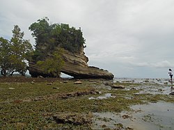
 The eponymous shoe-shaped rock formation at Sapatos Point in San Andres | |
 Map of Romblon with San Andres highlighted | |
Location within the Philippines | |
| Coordinates: 12°31′06″N 122°00′39″E / 12.5183°N 122.0108°E | |
| Country | Philippines |
| Region | Mimaropa |
| Province | Romblon |
| District | Lone district |
| Named for | Saint Andrew the Apostle |
| Barangays | 13 (see Barangays) |
| Government | |
| • Type | Sangguniang Bayan |
| • Mayor | Arsenio G. Gadon |
| • Vice Mayor | Joel G. Ibañez |
| • Representative | Eleandro Jesus F. Madrona |
| • Councilors |
|
| • Electorate | 11,600 voters (2022) |
| Area | |
• Total | 112.00 km2 (43.24 sq mi) |
| Elevation | 38 m (125 ft) |
| Highest elevation | 672 m (2,205 ft) |
| Lowest elevation | 0 m (0 ft) |
| Population (2020 census)[3] | |
• Total | 15,940 |
| • Density | 140/km2 (370/sq mi) |
| • Households | 4,094 |
| Economy | |
| • Income class | 5th municipal income class |
| • Poverty incidence | 35.60 |
| • Revenue | ₱ 97.96 million (2020) |
| • Assets | ₱ 279.5 million (2020) |
| • Expenditure | ₱ 77.92 million (2020) |
| • Liabilities | ₱ 80.41 million (2020) |
| Service provider | |
| • Electricity | Tablas Island Electric Cooperative (TIELCO) |
| Time zone | UTC+8 (PST) |
| ZIP code | 5501 |
| PSGC | |
| IDD : area code | +63 (0)42 |
| Native languages | Bantoanon Onhan Tagalog |
San Andres, officially the Municipality of San Andres, (formerly Parpagoja, Salado, and Despujols), is a 5th class municipality in the province of Romblon, Philippines. According to the 2020 census, it has a population of 15,940 people.[3]
- ^ Municipality of San Andres | (DILG)
- ^ "2015 Census of Population, Report No. 3 – Population, Land Area, and Population Density" (PDF). Philippine Statistics Authority. Quezon City, Philippines. August 2016. ISSN 0117-1453. Archived (PDF) from the original on May 25, 2021. Retrieved July 16, 2021.
- ^ a b Census of Population (2020). "Mimaropa". Total Population by Province, City, Municipality and Barangay. Philippine Statistics Authority. Retrieved 8 July 2021.
- ^ "PSA Releases the 2021 City and Municipal Level Poverty Estimates". Philippine Statistics Authority. 2 April 2024. Retrieved 28 April 2024.


