San Bernardino, CA | ||||||||||||||||||||||||||||||||||||||||||||||||||||||||
|---|---|---|---|---|---|---|---|---|---|---|---|---|---|---|---|---|---|---|---|---|---|---|---|---|---|---|---|---|---|---|---|---|---|---|---|---|---|---|---|---|---|---|---|---|---|---|---|---|---|---|---|---|---|---|---|---|
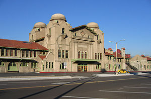
 Streetside of San Bernardino Santa Fe Depot in 2006 | ||||||||||||||||||||||||||||||||||||||||||||||||||||||||
| General information | ||||||||||||||||||||||||||||||||||||||||||||||||||||||||
| Other names | San Bernardino–Depot | |||||||||||||||||||||||||||||||||||||||||||||||||||||||
| Location | 1170 West Third Street[1] San Bernardino, California United States | |||||||||||||||||||||||||||||||||||||||||||||||||||||||
| Coordinates | 34°06′15″N 117°18′35″W / 34.10417°N 117.30972°W | |||||||||||||||||||||||||||||||||||||||||||||||||||||||
| Owned by | San Bernardino County Transportation Authority | |||||||||||||||||||||||||||||||||||||||||||||||||||||||
| Line(s) | BNSF Cajon / San Bernardino Subdivisions[2] | |||||||||||||||||||||||||||||||||||||||||||||||||||||||
| Platforms | 1 side platform (Amtrak) 3 island platforms (Metrolink) | |||||||||||||||||||||||||||||||||||||||||||||||||||||||
| Tracks | 7 | |||||||||||||||||||||||||||||||||||||||||||||||||||||||
| Connections | ||||||||||||||||||||||||||||||||||||||||||||||||||||||||
| Construction | ||||||||||||||||||||||||||||||||||||||||||||||||||||||||
| Parking | 777 spaces, 10 accessible spaces | |||||||||||||||||||||||||||||||||||||||||||||||||||||||
| Accessible | Yes | |||||||||||||||||||||||||||||||||||||||||||||||||||||||
| Other information | ||||||||||||||||||||||||||||||||||||||||||||||||||||||||
| Station code | Amtrak: SNB | |||||||||||||||||||||||||||||||||||||||||||||||||||||||
| History | ||||||||||||||||||||||||||||||||||||||||||||||||||||||||
| Opened | July 15, 1918 | |||||||||||||||||||||||||||||||||||||||||||||||||||||||
| Rebuilt | 2004 | |||||||||||||||||||||||||||||||||||||||||||||||||||||||
| Passengers | ||||||||||||||||||||||||||||||||||||||||||||||||||||||||
| FY 2023 | 16,403[7] (Amtrak only) | |||||||||||||||||||||||||||||||||||||||||||||||||||||||
| Services | ||||||||||||||||||||||||||||||||||||||||||||||||||||||||
| ||||||||||||||||||||||||||||||||||||||||||||||||||||||||
| ||||||||||||||||||||||||||||||||||||||||||||||||||||||||
Atchison, Topeka and Santa Fe Railway Passenger and Freight Depot | ||||||||||||||||||||||||||||||||||||||||||||||||||||||||
| Architect | W.A. Mohr; Cresmer Manufacturing Co. | |||||||||||||||||||||||||||||||||||||||||||||||||||||||
| Architectural style | Mission Revival/Moorish Revival/Spanish Colonial Revival | |||||||||||||||||||||||||||||||||||||||||||||||||||||||
| NRHP reference No. | 01000025 [8] | |||||||||||||||||||||||||||||||||||||||||||||||||||||||
| Added to NRHP | February 2, 2001 | |||||||||||||||||||||||||||||||||||||||||||||||||||||||
| ||||||||||||||||||||||||||||||||||||||||||||||||||||||||
The San Bernardino Santa Fe Depot (Metrolink designation San Bernardino–Depot) is a Mission Revival Style passenger rail terminal in San Bernardino, California, United States. It has been the primary station for the city, serving Amtrak today, and the Santa Fe and Union Pacific Railroads in the past. Until the mid-20th century, the Southern Pacific Railroad had a station 3/4 of a mile away.[9] It currently serves one Amtrak (Southwest Chief) and two Metrolink lines (Inland Empire–Orange County Line and San Bernardino Line). The depot is a historical landmark listed on the National Register of Historic Places as Atchison, Topeka and Santa Fe Railway Passenger and Freight Depot.[10]
- ^ "San Bernardino, CA (SNB)". amtrak.com. Amtrak. Retrieved January 11, 2014.
- ^ SMA Rail Consulting (April 2016). "California Passenger Rail Network Schematics" (PDF). California Department of Transportation. p. 19.
- ^ "Big Bear OTM Route 5".
- ^ "RIM OTM Route 6".
- ^ "Inter city route 15" (PDF). VVTA. Retrieved August 15, 2023.
- ^ "january2024 bus book" (PDF). Omnitrans. Retrieved April 24, 2024.
- ^ "Amtrak Fact Sheet, Fiscal Year 2023: State of California" (PDF). Amtrak. March 2024. Retrieved June 26, 2024.
- ^ "National Register Information System". National Register of Historic Places. National Park Service. April 15, 2008.
- ^ "Index of Railway Stations, p. 1444". Official Guide of the Railways. 82 (3). National Railway Publication Company. August 1949.
- ^ "California – San Bernardino County". www.nationalregisterofhistoricplaces.com. American Dreams, Inc. Retrieved January 11, 2014.
