| San Bruno Mountain | |
|---|---|
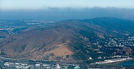
 Aerial view of San Bruno Mountain from San Francisco Bay overlooking part of Brisbane. | |
| Highest point | |
| Elevation | 1,319 ft (402 m) NAVD 88[1] |
| Prominence | 1,114 ft (340 m)[2] |
| Coordinates | 37°41′15″N 122°26′08″W / 37.687440278°N 122.435555036°W[1] |
| Geography | |
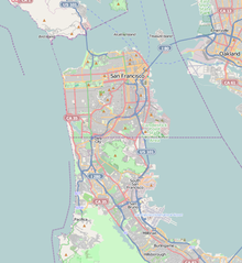
| Location | San Mateo County, California, U.S. |
| Topo map | USGS San Francisco South |
| Climbing | |
| Easiest route | Trail hike[3] |
San Bruno Mountain is a fault-block horst in northern San Mateo County, California. Rising to a quarter-mile high peak directly out of San Francisco Bay, it also includes a smaller ridge in San Francisco. Viewed from downtown San Francisco, the mountain occupies the southern horizon. It is surrounded as well by the cities of Brisbane, Colma, Daly City, and South San Francisco, and has an important role in the history and life of these communities.
From atop the four mile long ridge, summit trails afford expansive views of the San Francisco Bay Area. Much of the mountain is in the 2,326-acre (941 ha) San Bruno Mountain State Park or the adjoining 83-acre (34 ha) State Ecological Reserve. Radio Peak (elevation 1,319 feet or 402 meters),[1] the highest point, hosts radio/TV broadcast towers serving the hilly Bay Area.
San Bruno Mountain is not part of the nearby Santa Cruz Mountains, though their northern-most peak, Montara Mountain, is only eight miles from Radio Peak. The Santa Cruz range is on the Pacific tectonic plate, however, while San Bruno Mountain is on the North American Plate.
Distinct geology and weather set San Bruno Mountain apart from other California coastal areas.[4] The mountain soil provides habitat for rare and endangered plants (see below) and butterflies; the Callippe silverspot, Mission blue, and San Bruno elfin butterfly all inhabit mountain slopes.[5] The mountain is also a cradle for economically-useful plants; the low-growing evergreen "San Bruno Mountain Manzanita" (Arctostaphylos uva-ursi) has become widely used in drought-resistant landscaping.[6]
- ^ a b c "San Bruno Mountain Reset". NGS Data Sheet. National Geodetic Survey, National Oceanic and Atmospheric Administration, United States Department of Commerce. Retrieved 2009-06-24.
- ^ "San Bruno Mountain, California". Peakbagger.com. Retrieved 2009-08-24.
- ^ "San Bruno Mountain Summit Loop". Trailspotting. Retrieved 2009-08-24.
- ^ "California Department of Fish and Game's website, San Bruno Ecological Reserve".
- ^ Extracting useful data from imperfect monitoring schemes: endangered butterflies at San Bruno Mountain, San Mateo County, California (1982–2000) and implications for habitat management|Longcore et al.|2010 Springerlink.com|http://www.crecology.com/wp-content/uploads/2013/03/J.InsectConservation-Paper-01-07-2010.pdf
- ^ "Sustainable Conservation: BEYOND DROUGHT TOLERANT GUIDE".


