32°58′23.01″N 117°14′57.57″W / 32.9730583°N 117.2493250°W
| San Dieguito River Rio San Bernardo[1] | |
|---|---|
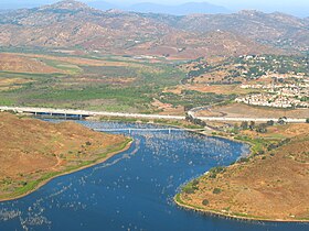
 The San Dieguito River entering Lake Hodges | |
 | |
| Etymology | Likely based on the name of San Diego River "ito" is the Spanish diminutive suffix for "little". Thus, Little San Diego River. |
| Location | |
| Country | United States |
| State | California |
| Region | Southern California |
| District | San Diego County |
| Municipality | Del Mar |
| Physical characteristics | |
| Source | Santa Ysabel Creek |
| 2nd source | Santa Maria Creek |
| Mouth | Pacific Ocean |
• location | Del Mar |
• elevation | 0 ft (0 m) |
| Length | 24 mi (39 km), northeast-southwest |
| Basin size | 346 sq mi (900 km2) |
| Discharge | |
| • average | 50 cu ft/s (1.4 m3/s) |
| • minimum | 0 cu ft/s (0 m3/s) |
| • maximum | 72,100 cu ft/s (2,040 m3/s)[2] |
| Basin features | |
| Tributaries | |
| • left | Santa Maria Creek |
| • right | Temescal Creek, San Diego County|Temescal Creek |
The San Dieguito River is a major river in Southern California, United States. Its headwaters rise on the southern slope of the Volcan Mountains in San Diego County, and the river flows generally southwest for 23.8 miles (38.3 km),[3] draining 346 square miles (900 km2) before emptying into the Pacific Ocean 20 miles (32 km) north of San Diego.[4]
- ^ Durham, David L. (1998). California's geographic names: a gazetteer of historic and modern names of the state. Sanger, CA: Word Dancer Press. p. 1337. ISBN 978-1-884995-14-9. Retrieved June 25, 2010.
- ^ Hill, Joseph (2002). "Dry Rivers, Dammed Rivers and Floods: An Early History of the Struggle Between Droughts and Floods in San Diego". The Journal of San Diego History. 48 (1). San Diego History Center. Archived from the original on February 19, 2003. Retrieved June 10, 2023.
- ^ U.S. Geological Survey. National Hydrography Dataset high-resolution flowline data. The National Map, accessed March 16, 2011
- ^ "San Dieguito Watershed". project clean water. Retrieved December 12, 2009.