San Dimas, California | |
|---|---|
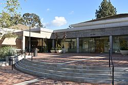
 City Hall (2017) | |
 Location within California and Los Angeles County | |
| Coordinates: 34°6′10″N 117°48′58″W / 34.10278°N 117.81611°W | |
| Country | |
| State | |
| County | Los Angeles |
| Incorporated | August 4, 1960[1] |
| Government | |
| • Type | City council/city manager[2] |
| • Mayor | Emmett Badar[3] |
| • City Manager | Chris Constantin[4] |
| Area | |
| • Total | 15.43 sq mi (39.96 km2) |
| • Land | 15.04 sq mi (38.95 km2) |
| • Water | 0.39 sq mi (1.01 km2) 2.53% |
| Elevation | 955 ft (291 m) |
| Population (2020) | |
| • Total | 34,924 |
| • Estimate (2021)[7] | 34,064 |
| • Density | 2,322.07/sq mi (896.64/km2) |
| Time zone | UTC-8 (PST) |
| • Summer (DST) | UTC-7 (PDT) |
| ZIP code | 91773[8] |
| Area code | 909[9] |
| FIPS code | 06-66070 |
| GNIS feature IDs | 1652785, 2411784 |
| Website | sandimasca.gov |
San Dimas (Spanish for "Saint Dismas")[10] is a city in the San Gabriel Valley of Los Angeles County, California, United States. At the 2020 census, its population was 34,924. It historically took its name from San Dimas Canyon in the San Gabriel Mountains above the northern section of present-day San Dimas.
San Dimas is bordered by the San Gabriel Mountains range to the north, Glendora and Covina to the west, La Verne to its north and east side, Pomona to its south and east side, Walnut and the unincorporated community of Ramona to the southwest, and the unincorporated community of West San Dimas, which is an enclave in the southwestern portion of the city.
- ^ "California Cities by Incorporation Date". California Association of Local Agency Formation Commissions. Archived from the original (Word) on November 3, 2014. Retrieved August 25, 2014.
- ^ "City Manager's Office". Retrieved December 2, 2017.
- ^ "City Council". City of San Dimas. Retrieved May 5, 2020.
- ^ "City Manager's Office" (PDF). City of San Dimas. Retrieved January 29, 2021.
- ^ "2019 U.S. Gazetteer Files". United States Census Bureau. Retrieved July 1, 2020.
- ^ "San Dimas". Geographic Names Information System. United States Geological Survey, United States Department of the Interior. Retrieved December 19, 2014.
- ^ Cite error: The named reference
USCensusEst2021CenPopScriptOnlyDirtyFixDoNotUsewas invoked but never defined (see the help page). - ^ "USPS – ZIP Code Lookup – Find a ZIP+ 4 Code By City Results". Retrieved January 18, 2007.
- ^ "Number Administration System – NPA and City/Town Search Results". Archived from the original on February 5, 2012. Retrieved January 18, 2007.
- ^ San Dimas Chamber of Commerce (October 2007). "A Brief History of San Dimas". California Historic Route 66 Association. Archived from the original on July 3, 2008.
