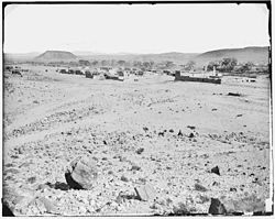
San Felipe Pueblo, New Mexico (Katishtya) | |
|---|---|
 San Felipe Pueblo | |
| Nickname: Katishtya | |
 Location of San Felipe Pueblo, New Mexico | |
| Coordinates: 35°25′37″N 106°26′37″W / 35.42694°N 106.44361°W | |
| Country | |
| State | |
| County | Sandoval |
| Area | |
| • Total | 12.26 sq mi (31.76 km2) |
| • Land | 11.98 sq mi (31.04 km2) |
| • Water | 0.28 sq mi (0.73 km2) |
| Elevation | 5,131 ft (1,564 m) |
| Population | |
| • Total | 2,542 |
| • Density | 212.13/sq mi (81.91/km2) |
| Time zone | UTC-7 (Mountain (MST)) |
| • Summer (DST) | UTC-6 (MDT) |
| Area code | 505 |
| FIPS code | 35-67450 |
| GNIS feature ID | 0928802 |
San Felipe Pueblo (Eastern Keres: Katishtya, Navajo Tsédááʼkin) is a census-designated place (CDP) in Sandoval County, New Mexico, United States, and is located 10 miles (16 km) north of Bernalillo. As of the 2000 census, the CDP population was 2,080. It is part of the Albuquerque Metropolitan Statistical Area.
- ^ "ArcGIS REST Services Directory". United States Census Bureau. Retrieved October 12, 2022.
- ^ Cite error: The named reference
USCensusDecennial2020CenPopScriptOnlywas invoked but never defined (see the help page).

