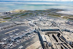
San Francisco International Airport | |||||||||||||||||||||||
|---|---|---|---|---|---|---|---|---|---|---|---|---|---|---|---|---|---|---|---|---|---|---|---|
 | |||||||||||||||||||||||
 Aerial view of San Francisco International Airport | |||||||||||||||||||||||
| Summary | |||||||||||||||||||||||
| Airport type | Public | ||||||||||||||||||||||
| Owner/Operator | City and County of San Francisco | ||||||||||||||||||||||
| Serves | San Francisco Bay Area | ||||||||||||||||||||||
| Location | San Mateo County, California, U.S. | ||||||||||||||||||||||
| Opened | May 7, 1927 | ||||||||||||||||||||||
| Hub for | |||||||||||||||||||||||
| Time zone | PST (UTC−08:00) | ||||||||||||||||||||||
| • Summer (DST) | PDT (UTC−07:00) | ||||||||||||||||||||||
| Elevation AMSL | 4 m / 13 ft | ||||||||||||||||||||||
| Coordinates | 37°37′08″N 122°22′30″W / 37.61889°N 122.37500°W | ||||||||||||||||||||||
| Website | www | ||||||||||||||||||||||
| Maps | |||||||||||||||||||||||
 FAA airport diagram | |||||||||||||||||||||||
 | |||||||||||||||||||||||
| Runways | |||||||||||||||||||||||
| |||||||||||||||||||||||
| Statistics (2023) | |||||||||||||||||||||||
| |||||||||||||||||||||||
San Francisco International Airport (IATA: SFO, ICAO: KSFO, FAA LID: SFO) is the primary international airport serving the San Francisco Bay Area in the U.S. state of California. It is located in an unincorporated area of San Mateo County,[3][4] and is about 12 miles southeast of San Francisco.
SFO is the largest airport in the San Francisco Bay Area and the second-busiest in the US State of California, after Los Angeles International Airport (LAX). In 2023, it was the fourteenth-busiest airport in the United States and the 29th-busiest in the world by passenger count.[5] It is the fifth-largest hub for United Airlines, functioning as the airline's primary transpacific gateway, and as a major maintenance hub. It also serves as a hub for Alaska Airlines.
The airport is owned and operated by the City and County of San Francisco and has a mailing address with a ZIP Code assigned to San Francisco. Between 1999 and 2004, the San Francisco Airport Commission operated city-owned SFO Enterprises Inc to oversee its business purchases and operations of ventures.[6][7][8][9]
- ^ "SFO Airport 2023 Final Air Traffic Summary" (PDF). flysfo.com. Retrieved July 4, 2024.
- ^ FAA Airport Form 5010 for SFO PDF, effective September 5, 2024
- ^ "2020 Census – Census Block Map: San Mateo County, CA" (PDF). Washington: U.S. Census Bureau. pp. 5–6 (PDF p. 6-7). Retrieved August 3, 2022.
San Francisco International Arprt
(airport directly indicated on page 6 (PDF page 7))
"San Francisco International Airport". Geographic Names Information System. United States Geological Survey, United States Department of the Interior. Retrieved May 3, 2009. - ^ "San Francisco International Airport". www.flysfo.com. March 16, 2022. Retrieved February 25, 2024.
- ^ Airports Council International – Worldwide Airport Traffic Report – Calendar Year 2017 (PDF) (Report). New York: The Port Authority of New York and New Jersey. Archived (PDF) from the original on May 8, 2018. Retrieved May 31, 2018.
- ^ Smith, Matt (March 28, 2001). "Flying Blind". SF Weekly. San Francisco: Black Press Ltd. Archived from the original on June 20, 2009. Retrieved August 3, 2009.
- ^ "Financial Audits". City and County of San Francisco. January 22, 2007. Archived from the original on November 26, 2009. Retrieved August 3, 2009.
- ^ "SFO Enterprises, Inc". SF Weekly. Archived from the original on July 26, 2011. Retrieved August 3, 2009.
- ^ The Shock Doctrine, Naomi Klein; pg. 396.